PACIFIC HIGHWAY
Section: Valla Beach to Raleigh
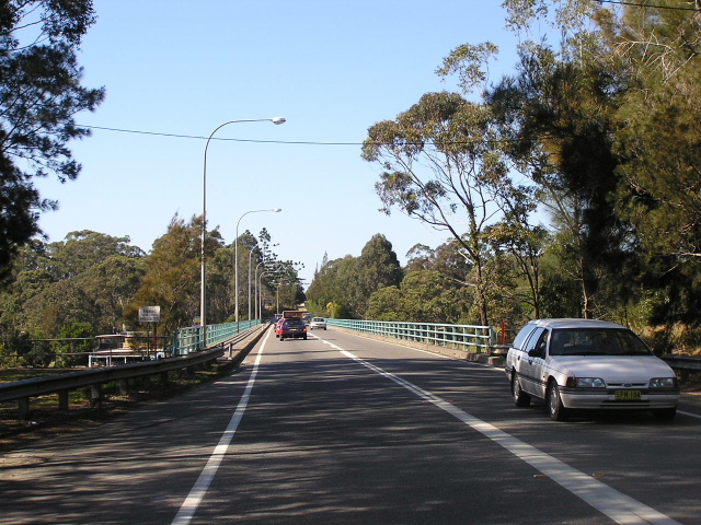
Looking south across the bridge over the Kalang River at Urunga. Aug 2004.
This 15km section of the Pacific Highway stretches from Valla beach Road to Short Cut Road , at the southern end of the Raleigh Deviation. It is currently single carriageway, except for a short section of divided road on the north side of the Kalang River .
Between Valla Beach Road and Urunga, the alignment of the highway has remained fallry static over the years, with only two alignment changes over the years. A section known as the "Long Cutting", south of Urunga, was eliminated by a 1mi. 520ft. long deviation in 1934-36. In 1958 a small deviation at McGraths Creek, south of the Newry State Forest , was completed. The original alignment of the highway remains as a local road serving several houses on the eastern side of the current highway. It has been named Wenonah Close.
In the vicinity of Hungry Head Rd the highway is characterized by a number of tight curves and in the early 21st century an upgrade of geometry signposting was effected, including the use of fluro paint on the warning signs. Also, three speed cameras were installed in the same timeframe along this section of road.
At Urunga, the Pacific Highway bypasses the town centre just to the west, however, the town has grown with ribbon development along the highway. The original alignment of the Pacific Highway through Urunga saw it leave the current route at Pilot Street, following Pilot Street across the railway line at Urunga Station, thence north along Orara Street and west along Bellingen Street to an oil-driven, six-car punt across the Kalang River. A bridge across the river was constructed by the Public Works Department in 1928, as the punt had become a point of congestion - newspaper reports of 1925 describe it as “very heavily trafficked”. There was some opposition from the local Progress Association over the location of the bridge, because it bypassed the town (the southern approach included a 1km deviation which eliminated two railway crossings and a circuitous route through Urunga town centre) and it was thought this would have an adverse impact on business. Nonetheless, the site was chosen as it was the most suitable to give least expensive construction and avoid the possibility of flooding and thus construction went ahead. The timber truss bridge was opened to traffic on 29 September 1929 .
Increasing traffic saw the need to replace the timber bridge appear in the 1960s and thus the Department of Main Roads began investigating possible bridge sites. A location immediately downstream from the timber bridge, and upstream from the railway bridge, was chosen and construction commenced in late 1970. The new bridge, a six-span, 752ft long concrete box-girder structure was opened to traffic on 13 March 1972 . The old bridge has since been demolished, although the former approaches are still trafficable.
North of the river, a short length of dived road was constructed as part of the Raleigh Deviation project which was opened to traffic on 17 September 1998.
Planning commenced in June 2003 for the Macksville-Urunga Upgrade, which would provide dual carriageway conditions along this section of the highway. Several options were put forward for a bypass of Urunga (as upgrading the existing highway to an appropriate standard would involve massive property acquisition) and in December 2005 a western bypass was selected as the preferred option. It will leave the existing highway at Mines Road, south of Urunga, rejoining the existing highway between Short Cut Road and the Waterfall Way on the Raleigh Deviation. An Environmental Impact Assessment is likely to commence by mid-2006.
 |
Looking north at Oyster Creek. Nov 2005. |
 |
Looking south towards McGraths Creek. The old alignment of the highway can be seen branching off to the left. Nov 2005. |
 |
Northbound AD sign approaching Hungry Head Rd. Note the fluro yellow warning signs in the background. Nov 2005. |
 |
Heading south towards Hungry Head Rd. The improvements to this winding section were funded by the Federal Government's black spot programme. Aug 2004. |
 |
ID sign at Pilot Street, pointing along the old highway route into Urunga town centre (Aug 1928-Sep 1928). Nov 2005. |
 |
Looking north through Urunga. Nov 2005. |
 |
Looking south through Urunga. Note the speed camera - one of three in a 9km section of the highway. Aug 2004. |
Construction of the bridge over the Kalang River at Urunga under construction in 1971. The old timber truss bridge can be seen directly behind the new bridge. (DMR). |
|
 |
The short section of divided road on the north side of the Kalang River, constructed as part of the Raleigh Deviation project in 1995-1998. Aug 2004. |
 |
Unusual placement of the NR1 shield on this AD sign, northbound approaching Short Cut Rd. Short Cut Rd - as the name suggests - is a short cut from the Pacific Hwy to the Waterfall Way and Bellingen, passing through the Raleigh Industrial Area. Following completion of the Raleigh Deviation, this AD sign was installed to discourage through traffic from using Short Cut Rd. Nov 2005. |