PACIFIC HIGHWAY
Section: Kempsey
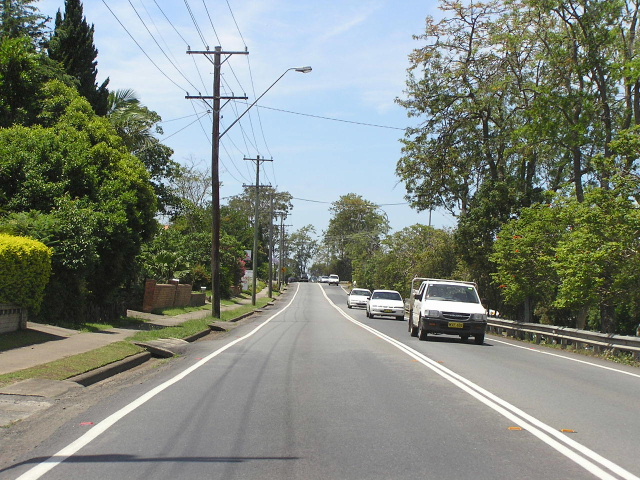
Looking north along a very narrow section of the highway (Lord St) in South Kempsey. Nov 2005.
This section of the Pacific Highway is 10km long, stretching from the northern end of the Maria River dual carriageways to the junction of the highway and Second Lane, 4km north of Kempsey town centre.
The southern approach to South Kempsey is a bit of a mystery to me. Lachlan Sims suggested that the Pacific Highway once entered South Kempsey via West End Road, which branches off the current alignment of the highway at a very suggestive angle near the Maria River . If this were the case, the Pacific Highway would have once traveled north along West End Rd, thence turned east into South Street to make its way to the old bridge over the North Coast Railway which was located just to the south east of the current bridge. I am yet to find evidence which either confirms or denies this, however what I can confirm is that the current route of the highway has been in use since at least 1975.
Once in South Kempsey, the Pacific Highway crosses two bridges (over Gills Ck and the North Coast Railway) between South Street and Crescent Head Rd that were constructed in 1985. Previously, the highway had crossed Gills Creek via a low-level bridge and the North Coast Railway via a bridge located just to the south east of the current bridge. The approaches to the old bridge still remain behind Gill Park and at the end of Angus McNeil Crescent.
Through South Kempsey, the route of the alignment has remained static since 1928, utilising the wide Lachlan Street and the very narrow Lord Street , which is perched high on a cliff lining the southern bank of the Macleay River .
The highway crosses the Macleay River on a steel truss bridge that is located adjacent to the eastern end of Belgrave Street and was opened to traffic on 21 November 1959. Prior to this, a timber truss bridge had crossed the river only a few metres downstream from the current bridge since 1900. Its importance the town was highlighted in the October 1949 flood when it stayed open after a car ferry narrowly avoided the piers of the bridge after it had taken out the railway bridge.
Through Kempsey town centre, the highway is locally known as Smith Street. It is surfaced with reinforced cement concrete, dating from the years immediately following the October 1949 Macleay River floods.
This section of the Pacific Highway falls under the scope of the Kempsey to Eungai Upgrade project, which will see the highway constructed on a new alignment, bypassing Kempsey to the east by several kilometres and including new high level bridges over the Macleay River and floodplain. In order to speed up the bypassing of Kempsey, the Kempsey to Eungai project was split into two stages, and a commencement made on the southern section in 2010. Including a 3.2km viaduct across the Macleay River and floodplain, this stage stretches for 14.5km between the existing highway at West End Road, south of Kempsey, and the existing highway just north of Frederickton. Completion is expected by the end of March 2013, weather permitting.
Photos - existing highway, pre-2010
 |
AD sign for Tourist Drive 12 (Crescent Head turnoff) northbound approaching the bridges over Gills Ck and the North Coast Railway. Nov 2005. |
 |
Looking northeast at the approaches to old bridge over the railway at South Kempsey, located just southeast of the current bridge. Nov 2005. |
 |
Looking northeast along the old highway pavement towards the approaches to the old bridge over the railway. Nov 2005. |
 |
Looking south from the junction with Crescent Head Rd, showing the old highway alignment (left) and the current alignment (right). Nov 2005. |
 |
Very old painted aggregate stockpile sign on the old highway alignment south of the railway line. These signs can be found in many areas between Kempsey and Coffs Harbour. Nov 2005. |
 |
Looking north along Lachlan Street through South Kempsey. Nov 2005. |
 |
Looking north approaching Rudder Street - the South West Rocks turnoff. Nov 2005. |
 |
The steel truss bridge over the Macleay River, as viewed from the park behind Big W. Nov 2005. |
 |
The view as you come off the bridge. To your left is Belgrave Street, which is part of Kempsey-Armidale Rd, and to the right is Smith St - the Pacific Highway. Nov 2005. |
 |
Southbound overhead signs approaching the Macleay River bridge from Smith St. Aug 2004. |
 |
Looking south on Pacific Hwy through the northern section of Kempsey. Aug 2004. |
 |
Sign assembly at the junction of the highway and Second Lane. Aug 2004. |
 |
Distance sign heading north from Second Lane. Nov 2005. |
Photos - construction of Kempsey Bypass (2010-2013)
July 2012 |
|
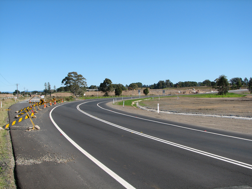
Looking southeast from McKays Lane at Pola Creek. Photo taken: July 2012. |
|
 |
Looking north along South West Rocks Road (MR198) at Pola Creek. Photo taken: July 2012. |
 |
Northwesterly view of the viaduct construction at South West Rocks Road, Pola Creek. Photo taken: July 2012. |
 |
A southerly view towards the main Macleay River spans from the existing Pacific Highway, 1km north of Frederickton. Photo taken: July 2012. |
 |
Looking southeast from the Frederickton Interchange towards the main Macleay River crossing. Photo taken: July 2012. |
 |
Another view from a similar spot, showing the earthworks for the extension of the bypass towards Eungai. Photo taken: July 2012. |
 |
Overpass at the Frederickton Interchange carrying a relocated section of the existing highway across the bypass. Photo taken: July 2012. |
 |
A southerly view along the existing highway, showing the relocated highway branching off to the right to cross the bypass at Frederickton Interchange. Photo taken: July 2012. |
 |
A northerly view at Frederickton Interchange. Note the patch covering 'Taree', which will be uncovered once the bypass opens. Photo taken: July 2012. |
 |
Southerly view of the southern half of the relocated highway at Frederickton Interchange. Photo taken: July 2012. |
 |
Looking northwest from the Frederickton Interchange, showing the path of the future bypass extension towards Eungai. Photo taken: July 2012. |
December 2012/January 2013 |
|
 |
Temporary traffic arrangements extend as far south as the Maria River, with highway traffic once again reverting to two-way traffic on the bridge constructed in the 1980s as the southbound carriageway. The bridge constructed to carry northbound traffic in 2008 is now operating as a one-way northbound service road until the work is completed. This view looks north across the Maria River. Photo taken: December 2012. |
 |
The physical works extend as far south as Stumpy Creek, 1km north of Maria River. This photo, looking south to the twin bridges over Stumpy Creek, shows traffic temporarily using the future southbound carriageway. Note the brand new concrete pavement which ends just before the bridge. Photo taken: December 2012. |
 |
Looking north along the future southbound carriageway, showing the stub for the future southbound on-ramp from the southern interchange. Two-way traffic is using this portion of the southbound carriageway. Photo taken: December 2012. |
 |
Looking south showing the future southbound off-ramp branching off to the left at the southern interchange. Photo taken: December 2012. |
 |
Looking north from near the above photo showing the bypass branching off to the right. Highway traffic is diverted via temporary works back onto the Pacific Highway into South Kempsey. Photo taken: December 2012. |
 |
A southerly view from the Frederickton Interchange towards the bridges over the Macleay River. Source: Peter Renshaw, December 2012. |
Photos - Kempsey Bypass after opening (2013-)
Northbound - April 2013 |
|
 |
Bypassed town signage northbound on Pacific Highway near Maria River, 2km south of the South Kempsey Interchange. Source: David Farlow, April 2013. |
 |
Temporary Variable Message Sign facing northbound traffic approaching the South Kempsey Interchange. The absence of Crescent Head from the large green direction signs resulted in numerous complaints in the weeks following the opening of the bypass. Source: David Farlow, April 2013. |
 |
Dodgy temporary sign facing northbound traffic just before the South Kempsey Interchange and the bridge over Stumpy Creek. Source: David Farlow, April 2013. |
 |
Looking north at the commencement of the Kempsey Bypass, the South Kempsey Interchange. The former highway route is being renamed Maclaey Valley Way. Source: David Farlow, April 2013. |
 |
Looking north beneath the overpass at the South Kempsey Interchange. Source: David Farlow, April 2013. |
 |
RD sign with dodgy National Route 1 coverplate, northbound on the Kempsey Bypass after the South Kempsey Interchange. Source: David Farlow, April 2013. |
 |
Looking north as the bypass crosses the North Coast Railway and then Pattersons Lane. Source: David Farlow, April 2013. |
 |
Looking north across Old Station Road. Source: David Farlow, April 2013. |
 |
Looking north towards the southern end of the bridge over the Maclaey River and floodplain. Source: David Farlow, April 2013. |
 |
Looking north across the Macleay River bridge. Source: David Farlow, April 2013. |
Last updated 8 June 2013 © Ozroads 2003-2013. |