State Route 123 Geraldton - Mount Magnet Road |

The first eastbound RD sign on Geraldton-Mt Magnet Road (SR123) at Geraldton. Photo taken: May 2010.
Introduced: 1986
Length: 335km
Eastern Terminus: Great Northern Highway & Geraldton-Mt Magnet Road, 5km south of Mount Magnet
Western Terminus: North West Coastal Highway & Geraldton-Mt Magnet Road, Geraldton
Route taken: Geraldton-Mt Magnet Road
Focal Points: Geraldton, Mullewa, Yalgoo, Mount Magnet
Main Roads Act 1930 classification: H50
Notable Events:
April 1986 - State Route 123 introduced1
Description:
State Route 123 is a major east-west route in the Mid-West region of Western Australia, connecting Geraldton with its immediate hinterland and the Mount Magnet, Meekatharra and Leinster mining areas.
The route commences at a signalised junction with the North West Coastal Highway about 2km from Geraldton City Centre. The first 8km or so runs east along a brand new, single-carriageway, controlled access route through Geraldton's main industrial area of Narngulu. Upon reaching the airport, the old road is rejoined and then the climb begins from the coastal plain at Moonyoonooka to the sand plain at Bringo. From Moonyoonooka eastwards the route closely follows the railway line through wheat country and crosses it several times. The Greenough River is crossed on a high level bridge at Eradu and from this point onward there are very few curves to Mullewa.
Mullewa, a very small and underwhelming township, is reached after 95km where major turnoffs to Mingenew, Gascoyne Junction and Morawa are located. A now disused railway line follows the road again eastwards from Mullewa, with tracks in situ as far as Pindar where the edge of the northern wheatbelt is reached. Beyond Pindar, the landscape transitions from rolling wheatfields to red earth and inhospitable scrub. The road gets straighter and traffic volumes are much lower. The parallel rail line loses its tracks but the formation is still clear, as are the remnants of numerous culverts and small bridges.
Yalgoo feels like an oasis when it is reached after 120km. The old railway station building has been converted to form part of the racecourse and a nice picnic area is available in the main street. East of Yalgoo, the road continues much as before - long straights with rolling crests and very little traffic. After another 120km slog without a settlement to speak of, the route gently curves to a T-junction at the Great Northern Highway, a couple of kilometres south of Mt Magnet. From this point, most traffic continues into Mt Magnet and then either northwards to Meekatharra or eastwards to Sandstone, Agnew and Leinster.
History:
Coming soon...
What's in a name?
Several years ago, following the completion of a sealed road between Mount Magnet, Sandstone and Leinster, there was a move to rename the entire route from Geraldton to Leinster as the Murchison Highway.2 However, nothing seems to have come from it.
References:
1. Main Roads Department, Annual Report 1985/86, p. 16
2. Shire of Mullewa, Minutes of Ordinary Meeting of Council, 20 September 2000, p. 10
|
Photos of State Route 123 |
|
 |
AD sign eastbound on North West Coastal Highway approaching the junction with Geraldton-Mt Magnet Road, Geraldton. The bridge in the background carries a realigned Durlacher Street across the highway. |
 |
AD sign southbound on North West Coastal Highway approaching the junction with Geraldton-Mt Magnet Road, Geraldton. Note that the through destinations are 'Perth' and 'City Centre', not 'Perth City Centre' - Perth's still over 4 hours away. |
 |
ID sign assembly facing southbound traffic at the junction of North West Coastal Highway & Geraldton-Mt Magnet Road, Geraldton. Photo taken: May 2010. |
 |
AD sign westbound on Geraldton-Mt Magnet Rd, approaching its terminus at North West Coastal Highway, Geraldton. |
 |
RD sign eastbound on Geraldton-Mt Magnet Rd near the junction with North West Coastal Highway, Geraldton. Photo taken: May 2010. |
 |
Geraldton-Mt Magnet Road looking east towards the Highbury Street overpass, which links the suburbs of Mount Tarcoola and Rangeway in southern Geraldton. Note the formation ready for future duplication and the Geraldton-Narngulu railway on the right. Photo taken: May 2010. |
 |
Geraldton-Mt Magnet Road looking east towards the junction with Edward Road at Narngulu. Narngulu is Geraldton's largest industrial area and an important intermodal terminal. |
 |
AD sign northbound on Edward Road approaching the junction with Geraldton-Mt Magnet Road at Narngulu. Photo taken: May 2010. |
 |
AD sign westbound on Geraldton-Mt Magnet Road approaching the junction with Edward Road at Narngulu. Photo taken: May 2010. |
 |
Geraldton-Mt Magnet Road looking east towards Geraldton Airport. Photo taken: May 2010. |
 |
ID sign at the junction of Geraldton-Mt Magnet Road & Deepdale Road near Geraldton Airport. Deepdale Road provides a link between the current alignment the old alignment (Horwood Road). Photo taken: May 2010. |
 |
Geraldton-Mt Magnet Road looking east at the entrance to Geraldton Airport. Photo taken: May 2010. |
 |
ID signs at the intersection of Geraldton-Mt Magnet Road & Gordon Garratt Drive, Geraldton Airport. Photo taken: May 2010. |
 |
AD sign westbound on Geraldton-Mt Magnet Road approaching Geraldton Airport. You can see the old alignment of Geraldton-Mt Magnet Road branching off to the right in the foreground. Photo taken: March 2011. |
 |
Geraldton-Mt Magnet Road looking east from the edge of the Geraldton urban area, towards the first hill climb at Moonyoonooka. Note the 'New Speed Limit Ahead' sign - this section was recently reduced from 110km/h to 90km/h. Photo taken: March 2011. |
 |
Geraldton-Mt Magnet Road looking west down the hill at Moonyoonooka towards Geraldton. The hangars and sheds at Geraldton Airport can be seen on the left. Photo taken: March 2011. |
 |
Geraldton-Mt Magnet Road looking east as you climb from the coastal plain at Moonyoonooka. A number of overtaking lanes on this have these signs which assist motorists in deciding whether to overtake a long vehicle or not. Photo taken: March 2011. |
 |
Old, black, 'MW80' kilometre plate and another overtaking lane as the route continues to climb, 20km east of Geraldton. Photo taken: March 2011. |
Undulating road alongside the Geraldton-Mullewa railway line, 22km east of Geraldton. Photo taken: March 2011. |
|
 |
Geraldton-Mt Magnet Road looking east as it ascends the Kojarena Range at Bringo, 25km east of Geraldton. Photo taken: March 2011. |
 |
Geraldton-Mt Magnet Road looking east at the top of the climb at Bringo, 26km east of Geraldton. Photo taken: March 2011. |
 |
Geraldton-Mt Magnet Road looking east, 30km east of Geraldton. Photo taken: March 2011. |
 |
Geraldton-Mt Magnet Road looking east as it descends the Kojarena Range towards the Greenough River crossing. Photo taken: March 2011. |
 |
Geraldton-Mt Magnet Road looking east at Wicherina on the descent into the Greenough River valley. Note the level crossing of the Geraldton-Mullewa railway line - this line originally extended all the way to Wiluna via Mt Magnet and Meekatharra, however these days it terminates at Mullewa. Photo taken: March 2011. |
 |
Geraldton-Mt Magnet Road looking east across the Greenough River. This bridge was constructed in 19651, replacing a low level crossing which was subject to flooding. Photo taken: March 2011. |
 |
Geraldton-Mt Magnet Road looking west at the one-time location of Chango siding. A railway realignment in 1934-352 introduced two level crossings in this area as the line now skirts the southern side of the hill to ease the grades. Note the old road alignment on the left which dates from the previous policy of providing curves to slow traffic down on approach to level crossings. Photo taken: March 2011. |
 |
Geraldton-Mt Magnet Road looking east towards the level crossing 3km east of Chango siding, 70km east of Geraldton. Photo taken: March 2011. |
 |
RD sign westbound on Geraldton-Mt Magnet Road at Tenindewa, 80km east of Geraldton. |
 |
Black ID sign at the junction of Geraldton-Mt Magnet Road & Yuna Tenindewa Road, Tenindewa. Photo taken: March 2011. |
 |
Typical rural AD sign westbound on Geraldton-Mt Magnet Road approaching the junction with Yuna Tenindewa Road, Tenindewa. Photo taken: March 2011. |
 |
RD sign eastbound on Geraldton-Mt Magnet Road at Tenindewa. Photo taken: March 2011. |
 |
SR123 trailblazer eastbound on Geraldton-Mt Magnet Road, 87km east of Geraldton. Photo taken: March 2011. |
 |
RD sign westbound on Geraldton-Mt Magnet Road near the junction with Mingenew Mullewa Road, 3km west of Mullewa. Photo taken: March 2011. |
 |
Black ID sign at the junction of Geraldton-Mt Magnet Road & Mingenew Mullewa Road, 3km west of Mullewa. Photo taken: May 2010. |
 |
Geraldton-Mt Magnet Road looking west towards the junction with Mingenew Mullewa Road, 3km west of Mullewa. Photo taken: March 2011. |
 |
Lovely old black RD sign eastbound on Geraldton-Mt Magnet Road, 3km west of Mullewa. Note the warning sign in the background for yet another level crossing. Photo taken: March 2011. |
 |
RD sign westbound on Geraldton-Mt Magnet Road on the western outskirts of Mullewa. Photo taken: March 2011. |
 |
Geraldton-Mt Magnet Road (Grey Street) looking northeast into Mullewa. Photo taken: March 2011. |
 |
Geraldton-Mt Magnet Road (Grey Street) looking northeast towards the junction with Jose Street, Mullewa. Photo taken: March 2011. |
 |
ID sign assembly at the intersection of Geraldton-Mt Magnet Road (Grey Street) & Jose Street, Mullewa. Photo taken: May 2010. |
 |
Geraldton-Mt Magnet Road looking west through Mullewa. The building with the pink roof is the Railway Hotel. Photo taken: March 2011. |
 |
Geraldton-Mt Magnet Road (Maitland Road) looking west through the western part of Mullewa. Note the sign - these seem to be the equivalent of NSW's 'Driver Reviver' signs, however I never did work out where to get the free coffee from. Photo taken: March 2011. |
 |
Geraldton-Mt Magnet Road looking east towards the junctions with Warren Road & Wubin Mullewa Road on the eastern edge of Mullewa. Photo taken: March 2011. |
 |
ID sign assembly at the intersection of Geraldton-Mt Magnet Road & Warren Road, Mullewa. Warren Road is the heavy vehicle route for the Carnarvon Mullewa Road, avoiding the town centre on Jose Street. Photo taken: March 2011. |
  |
ID signs at the junction of Geraldton-Mt Magnet Road & Wubin Mullewa Road, Mullewa. The large Mullewa grain handling facility is located to the left of the road in the top photo. Top photo: March 2011. Bottom photo: May 2010. |
 |
AD sign westbound on Geraldton-Mt Magnet Road approaching the junction with Wubin Mullewa Road, Mullewa. Photo taken: March 2011. |
 |
RD sign eastbound on Geraldton-Mt Magnet Road as you leave Mullewa. Photo taken: May 2010. |
 |
Geraldton-Mt Magnet Road looking east at the disused level crossing over the former Mullewa-Meekatharra railway line, 10km east of Mullewa. Although out of use for some time, the track remains on this line between Mullewa and Pindar. Photo taken: May 2010. |
 |
Geraldton-Mt Magnet Road looking east towards the small locality of Pindar, 30km east of Mullewa. Photo taken: May 2010. |
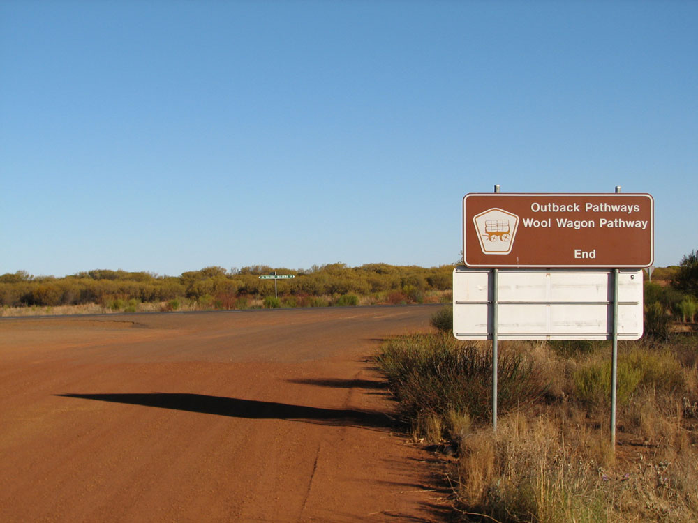 |
Tourist signage for the 'Wool Wagon Pathway' themed tourist route on Beringarra Pindar Road at the junction with Geraldton-Mt Magnet Road, Pindar. Photo taken: May 2010. |
 |
Geraldton-Mt Magnet Road looking west, 40km east of Mullewa. Photo taken: May 2010. |
 |
Geraldton-Mt Magnet Road looking west, 42km east of Mullewa. The long straights as you climb up and down a succession of low ridges are typical of the route between Mullewa and Mt Magnet. Photo taken: May 2010. |
 |
Geraldton-Mt Magnet Road looking east, 57km east of Mullewa. Photo taken: May 2010. |
 |
Geraldton-Mt Magnet Road looking west near Wuraga, 77km east of Mullewa. The cattle grid shows we're in pastoral country. Photo taken: May 2010. |
 |
Geraldton-Mt Magnet Road looking east as you descend from Wuraga towards Yalgoo, 86km east of Mullewa/33km west of Yalgoo. Photo taken: May 2010. |
 |
RD sign westbound on Geraldton-Mt Magnet Road as you leave Yalgoo. Photo taken: May 2010. |
 |
Geraldton-Mt Magnet Road looking east towards the junction with Morawa Yalgoo Road on the western edge of Yalgoo. Photo taken: May 2010. |
 |
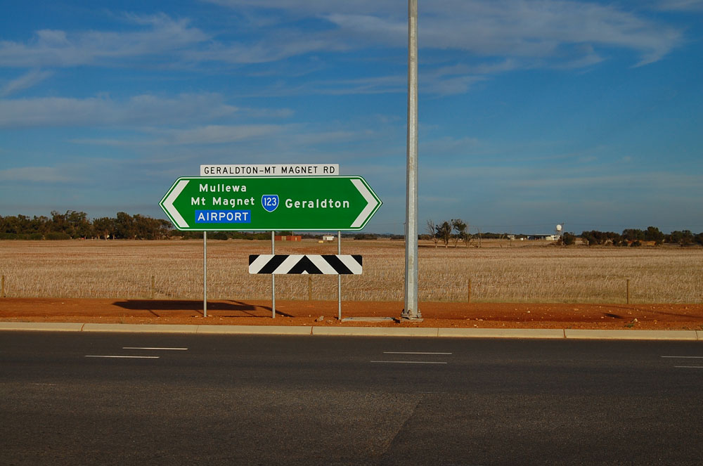
Combination of fingerboard and ID signs at the junction of Geraldton-Mt Magnet Road & Morawa Yalgoo Road near Yalgoo. Photo taken: May 2010. |
 |
Geraldton-Mt Magnet Road looking east through Yalgoo. The 'town centre' is located to the left, whilst a 24hr card-operated petrol station is located on the right, next to the old railway station. Photo taken: May 2010. |
 |
Yalgoo is a fair way from anywhere - black fingerboard signs at the junction of Geraldton-Mt Magnet Road (Piesse Street) & Gibbons Street, Yalgoo. Photo taken: May 2010. |
 |
Geraldton-Mt Magnet Road looking east from Gibbons Street, Yalgoo, with the petrol station and old railway station on the right. Photo taken: May 2010. |
 |
RD sign eastbound on Geraldton-Mt Magnet Road as you leave Yalgoo. Photo taken: May 2010. |
 |
Geraldton-Mt Magnet Road looking west into Yalgoo. Photo taken: May 2010. |
  |
Sign assembly at the junction of Geraldton-Mt Magnet Road & Yalgoo Ninghan Road, 2km east of Yalgoo. The brown signage refers to the 'Miners Pathway' themed tourist route, which is actually better signed than SR123 is in this area! Phoos taken: May 2010. |
 |
Older service sign westbound on Geraldton-Mt Magnet Road, 5km east of Yalgoo. The hospital symbol actually refers to a Nursing Post, not an actual hospital. Photo taken: May 2010. |
 |
Typical view of Geraldton-Mt Magnet Road, looking west, 15km east of Yalgoo. The crumbling remains of the Wagga Wagga railway platform and loading facilities are located nearby. Photo taken: May 2010. |
 |
Geraldton-Mt Magnet Road looking east, showing a section raised above the natural ground level to avoid flooding, 15km east of Yalgoo. Photo taken: May 2010. |
 |
Geraldton-Mt Magnet Road looking west near Munbinia, 70km east of Yalgoo. Photo taken: May 2010. |
 |
SR123 trailblazer facing eastbound traffic, 110km east of Yalgoo/11km west of the Great Northern Highway junction. This is the only trailblazer on this route east of Mullewa. Photo taken: May 2010. |
 |
Services signage westbound on Geraldton-Mt Magnet Road near the junction with Great Northern Highway, 8km west of Mt Magnet. Note the relatively narrow pavement. Photo taken: May 2010. |
 |
Geraldton-Mt Magnet Road looking west near the junction with Great Northern Highway, 6km west of Mt Magnet. The services sign from the previous photo can be seen in the distance. Photo taken: May 2010. |
 |
Services signage facing eastbound traffic approaching the junction with Great Northern Highway, 5km west of Mt Magnet. It is stupid that this sign refers to Paynes Find (located to the south) and not to Sandstone, which is located on the natural westward continuation of this route. Photo taken: May 2010. |
 |
RD sign westbound on Geraldton-Mt Magnet Road as you leave the junction with Great Northern Highway, 2km west of Mt Magnet. Photo taken: May 2010. |
 |
AD sign eastbound on Geraldton-Mt Magnet Road approaching the junction with Great Northern Highway. Photo taken: May 2010. |
  |
ID sign assembly at the junction of Great Northern Highway & Geraldton-Mt Magnet Road, 2km southwest of Mt Magnet. Note the ID sign refers to Wubin, whereas the AD sign referred to Paynes Find! The trailblazer marks the way for the 'Miners Pathway' themed tourist route. Photo taken: May 2010. |
 |
AD sign southbound on Great Northern Highway approaching the junction with Geraldton-Mt Magnet Road. Note the incorrect NR95 shield. Photo taken: May 2010. |
 |
AD sign northbound on Great Northern Highway approaching the junction with Geraldton-Mt Magnet Road. Photo taken: May 2010. |

References:
1. Main Roads Department, file 1964/783 - Geraldton-Mullewa Road No. 520. Bridge at Eradu Crossing - Tenders. Greenough Shire Council. SROWA, Cons 1838.
2. Jeff Austin, "Centenary of the Narngulu-Mullewa Railway", Westland 119 (December 1994), p. 11
View Ozroads - WA SR123 bypassed section at Geraldton in a larger map
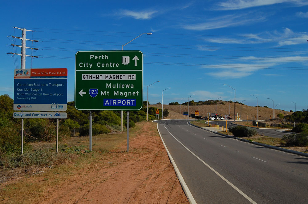
On the eastern approach to Geraldton, State Route 123 follows a brand new route opened in 2010. Constructed as Stage 2 of the 'Geraldton Southern Transport Corridor' project, this 8.5km long section of Geraldton-Mt Magnet Road provides a controlled-access route from the eastern edge of the urban area to the North West Coastal Highway and onwards to the port.
Prior to 2010, State Route 123 entered Geraldton via what is now Horwood Road, Eastward Road and Utakarra Road. This route passed through the main industrial area but also through the residential suburb of Rangeway. Uncontrolled property access, a level crossing and numerous intersections meant significant conflicts between local traffic and heavy vehicles, particularly road trains, hauling wheat and minerals to the port.
As at October 2012, many of the State Route 123 signs along the bypassed section were yet be removed or coverplated. These signs, along with streetscapes of the bypassed section of State Route 123, can be viewed below.
 |
North West Coastal Highway looking north towards the junction with Utakarra Road at Rangeway. This intersection was formerly the western terminus of State Route 123. Photo taken: May 2010. |
 |
Despite all the other direction signs at this intersection being removed once the new alignment was opened, this beautiful old black AD sign remains facing westbound traffic on Utakarra Road, approaching the junction with North West Coastal Highway. Photo taken: March 2011. |
 |
Utakarra Road looking east through the suburb of Rangeway. Note the school crossing just beyond the intersection - this mix of local and heavy traffic created the need for the new alignment. Photo taken: March 2011. |
 |
Remnant SR123 RD sign eastbound on Utakarra Road near the junction with Rifle Range Road, Rangeway. Photo taken: May 2010. |
 |
Utakarra Road looking east as you descend from the ridge at Rangeway. Note the climbing lane - originally provided to reduce the traffic impacts of heavy vehicles on this section of the route. Photo taken: May 2010. |
 |
Remnant SR123 RD sign westbound on Eastward Road near the junction with Flores Road, Utakarra. Photo taken: May 2010. |
 |
Eastward Road looking east across the now removed level crossing of the former Geraldton-Narngulu railway line at Utakarra. As part of the Geraldton Southern Transport Corridor project, a new railway line was constructed between Geraldton port and Narngulu, allowing the original line, which separated the City Centre from the foreshore, to be closed and pulled up. Photo taken: May 2010. |
 |
ID sign at the junction of Horwood Road & Edward Road, Utakarra, with remnant SR123 shield. The name plate was replaced but for some reason the SR123 shield was not covered - although I'm hardly complaining! Photo taken: May 2010. |
 |
Horwood Road westbound approaching the junction with Woorree Lane - the AD sign refers to the junction with Edward Road which is located just beyond the bend. Photo taken: March 2011. |
 |
Remnant SR123 RD sign eastbound on Horwood Road at Utakarra. Photo taken: May 2010. |
 |
Remnant 'G10' kilometre plate westbound on Horwood Road at Deepdale. Photo taken: March 2011. |
 |
Remnant 'MW90' kilometre plate eastbound on Horwood Road at Deepdale. The junction of the old and new alignment is located at the end of this long straight. Photo taken: May 2010. |
 |
ID sign assembly at the junction of Horwood Road & Deepdale Road, Deepdale. Deepdale Road provides a link between the old and new alignments. Note the hastily added 'Airport' patch. Photo taken: May 2010. |
 |
The end of the road - Horwood Road looking east where the old and new alignments join, just east of the Geraldton Airport entrance. Photo taken: May 2010. |
 |
Geraldton-Mt Magnet Road looking west at the junction of the old and new alignments, just east of the Geraldton Airport entrance. Photo taken: May 2010. |

At Bringo, 25km east of Geraldton, the Geraldton-Mt Magnet Road ascends the Kojarena Range separating the coastal and sand plains. This is the steepest climb along the entire route.
As you can see from the photos below, the old route consisted of a long straight followed by a short and sharp curving ascent to the top. As the length, weight and volume of traffic increased, the 'Bringo Jump-up' became more and more of an issue.
Following the completion of sealing works along the route in 1982, attention turned to improving the older sections closer to Geraldton. With funding from the Australian Bicentennial Road Development (ABRD) programme, complete reconstruction and widening of a 3.3km section of the road at Bringo was commenced in May 1985.1 This project included a 1.5km long deviation to bypass the main part of the climb, considerably straightening the alignment.
The new alignment is steeper than the old, however it has a much improved horizontal alignment and an overtaking lane for eastbound traffic. The deviation was completed in November 1985.2
 |
Looking east along the old alignment from its western end. Photo taken: March 2011. |
 |
Looking west at the western end of the old alignment. The pavement ends just beyond the crest, rejoining the present alignment. Photo taken: March 2011. |
 |
Another easterly view along the old alignment from near the western end. The gravel track branching off to the right may be an older alignment. Photo taken: March 2011. |
 |
A westerly view from just past the end of the above straight, at the bottom of the descent. Photo taken: March 2011. |
 |
An easterly view as the old road curves its way up the ridge. Photo taken: March 2011. |
 |
An easterly view of the s-curve as the old road approaches the top of the ridge, in the distance. Photo taken: March 2011. |
 |
A southerly view from near the top of the ridge, showing the descent. Photo taken: March 2011. |
 |
A westerly view along the present alignment, showing the beginning of the deviation as it curves to the right. The road originally continued pretty much straight ahead at this point. Photo taken: March 2011. |
References:
1. Main Roads Department, Annual Report 1984/85, p. 39
2. Main Roads Department, Annual Report 1985/86, p. 46
Last updated 23 December 2012 © Ozroads 2003-2012. |