ALTERNATIVE NATIONAL ROUTE 1
Formerly Southern Ports Highway, SA
Remnant Alt-1 RD sign, heading south-east from Robe. Jan 2005.
Lifespan: 1978-1999 (21 years)
Length: 121km
Northern Terminus: Princes Hwy & Southern Ports Hwy, Kingston SE
Southern Terminus: Princes Hwy & Williams Rd (Southern Ports Hwy), Millicent
Route taken: Southern Ports Highway. Note: Alt-1 did not enter either Robe or Beachport
Focal Points: Kingston SE, Robe, Beachport, Millicent
Alternative National Route 1 was signed along the Southern Ports Highway during 1977/78, probably as an effort to boost tourism along the Southern Ports. The Southern Ports Highway was actually the original route of the Princes Highway until 1933 when the existing Princes Highway alignment between Millicent and Kingston S.E was constructed. Alt-NR1 was decommissioned in 1999 when SA began its alpha0numeric route marking scheme and was replaced in its entirity by route B101. As you can see by the photos below, there are still many remnants of Alt-1 as TSA take forever to change over their signs.
Remnants of Alternative National Route 1 along the Southern Ports Hwy, SA |
|
 |
Alt-1 shield on a distance sign on Princes Hwy about 200km north of its northern terminus, at the B45 - Fleurieu Way near Wellington. There was another one at the Dukes Hwy intersection in Tailem Bend, however it had been coverplated. Jan 2005. |
 |
Heading south from Kingston S.E. Note the much easier to read Alt-1 shield. Jan 2005. |
 |
Heading north from Robe. Jan 2005. |
 |
Heading east approaching the Robe-Penola Rd about 15km east of Robe. Jan 2005. |
 |
Heading south from the same intersection. Jan 2005. |
 |
Heading south at the Beachport-Penola Rd near Beachport. Jan 2005. |
 |
Heading north to the same intersection. Compare this style of shield with that in the above photo. This one is much harder to read. Jan 2005. |
 |
Looking south approaching the access road to Beachport. Jan 2005. |
 |
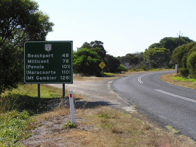
Looking east from Beachport towards Millicent. Jan 2005. |
 |
Looking west from Millicent. Jan 2005. |
 |
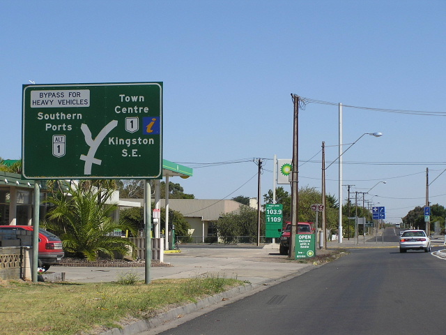
Unusual method of signposting at this intersection. Alt-1 (and the Southern Ports Hwy) turns right at this intersection, yet the through focal point (Mt Gambier) is signed through the town centre. Intersection of Rendelsham Rd & Williams Rd, Millicent. Jan 2005. |
 |
Unusually large Alt-1 shield on an older directional sign at the same intersection. Jan 2005. |
 |
Looking west along Williams Rd (Southern Ports Hwy) from the Princes Hwy at Millicent. Jan 2005. |
 |
Early 1990s sign heading west on Princes Hwy approaching the Southern Ports Hwy in Millicent. Jan 2005. |
 |
Original 1978 sign at the same location as the above photo. Jan 2005. |
 |
Another original 1978 sign, this time at the intersection of Princes Hwy & Ridge Tce, Millicent. Jan 2005. |