State Route 86 Maryborough - Biggenden |
RD sign heading west on Maryborough-Biggenden Road, west of Bruce Highway. Photo taken:July 2008.
Introduced: 1990s
Length: 83km
Eastern Terminus: Ferry Street & Alice Street, Maryborough
Western Terminus: Isis Highway & George Street, Biggenden
Route taken: Alice Street, Maryborough-Biggenden Road, George Street
Focal Points: Maryborough, Biggenden
Transport Infrastructure Act 1994 classification: 478 Maryborough-Biggenden Road (Maryborough-Brooweena & Boompa-Biggenden), 487 Brooweena-Woolooga Road (Brooweena to Woolooga turnoff), 479 Boompa Road (Woolooga turnoff-Boompa)
Notable Events:
1990 - introduction of State Route 571
September 1990 - Opening of Maryborough Bypass (Bruce Highway) and relocation of National Highway Route 12
Description:
State Route 86 is a relatively minor east-west route linking Maryborough with the North Burnett region at Biggenden. It provides one of two routes linking the North Burnett with the Fraser Coast, as well as serving a number of mines in the Biggenden area.
Commencing at the junction with Ferry Street (State Route 57) in Maryborough, State Route 86 heads westwards along Alice Street, which is the former route of Bruce Highway prior to construction of the Maryborough Bypass. After crossing the Bruce Highway via an elevated roundabout, the route then passes through semi-rural Maryborough West, then through undulating farmland, then finally through thickly forested areas at the foot of the Sea View Range. This section of the route is characterised by a number of long steep straights as it crosses a number of creek valleys.
Reaching the small village of Brooweena, an unusual section of the route is encountered. Just beyond Brooweena, a sharp bend is encountered where the route turns southwards. After heading south for 6km, a junction is then reached where the route turns right (west) towards Biggenden. After crossing Sandy and Eel Creeks, the route then turns northwards towards Boompa, with this section of the road alternating between single-lane and two-lane wide seal. Upon reaching the former railway siding at Boompa, another sharp bend is encountered, with the route turning sharply west to regain its east-west orientation. The mountain range between Brooweena and Boompa is the obvious reason for this strange deviation but it is not clear why a route roughly parallel to the railway has never been constructed.
From Boompa to Biggenden, the route is much flatter and straighter as it passes through farmland alongside Mt Walsh. Only one relatively short section of single-lane seal is encountered before the Fraser Coast/North Burnett LGA boundary.
References:
1. In typical Queensland fashion, the introduction date of this route is hard to determine. State Route 86 first appears in the June 1989 edition of Guide to Queensland Roads, however this is no certainty that it was comprehensively signed at this time. It is unlikely that a major signposting scheme on this route would have been implemented until the opening of the Maryborough Bypass and associated re-routing of National Highway Route 1. This project opened in September 1990 so I have therefore assumed an indicative date of 1990 for the introduction of State Route 86. Interestingly, RAC maps of this area do not show SR86 until well into the 1990s.
2. Queensland Department of Main Roads, Annual Report 1989/1990, p. 35 - notes that the project is on track for a September 1990 opening
|
Photos of State Route 86 (Maryborough to Biggenden) |
|
 |
AD sign southbound on Ferry Street approaching the junction with Alice Street, Maryborough. This junction forms the eastern terminus of State Route 86. |
 |
AD sign, acting as an ID sign, facing southbound traffic at the junction of Ferry & Alice Streets, Maryborough. The sign incorrectly shows State Route 86 in both directions - it should only show the route for the right turn. |
 |
Non-standard ID sign at the junction of Ferry & Alice Streets, Maryborough. The 'To Bruce Highway via Alice Street' legend really should be in a supplementary sign. Photo taken: July 2008. |
 |
AD sign eastbound on Alice Street marking the eastern terminus of State Route 86 at Ferry Street, Maryborough. Note that the bottom panel should have a blue background, not green, and should probably be located on the top of the sign. |
 |
RD sign westbound on Alice Street after the junction with Ferry Street, Maryborough. The focal points of Childers and Bundaberg reflect Alice Street's former role as part of Bruce Highway. Photo taken: July 2008. |
 |
RD sign eastbound on Alice Street at the junction with Bruce Highway (Maryborough bypass section), 3km west of Maryborough. Just beyond the cutting in the distance is the location where the old alignment of Bruce Highway joins Alice Street - this section of road was constructed as part of the Maryborough bypass project. Photo taken: July 2008. |
 |
AD sign westbound on Alice Street approaching the elevated roundabout interchange at the Bruce Highway. Note the narrow format National Highway route shields, the use of which has now been discontinued in Queensland. Photo taken: July 2008. |
| Southbound signage on Bruce Highway approaching the junction with Alice Street & Gayndah Road, 3km west of Maryborough. Typical ugly Queensland signs! | |
   |
Northbound signage on Bruce Highway approaching the junction with Alice Street & Gayndah Road, 3km west of Maryborough. Note the speed reduction through the interchange due to the lower standard road and at-grade intersections north of the railway. Photos taken: July 2008. |
 |
ID sign facing southbound traffic at the junction of Bruce Highway, Alice Street & Gayndah Road. Photo taken: July 2008. |
 |
Dodgy ID sign facing westbound traffic at the junction of Bruce Highway, Alice Street & Gayndah Road. Photo taken: July 2008. |
 |
AD sign, still fresh with overnight dew, eastbound on Gayndah Road approaching the junction with Bruce Highway, 3km west of Maryborough. Photo taken: July 2008. |
 |
RD sign westbound on Gayndah Road after the junction with Bruce Highway. As the sign suggests, there are no settlements of any significance between Maryborough and Biggenden. Photo taken: July 2008. |
 |
Gayndah Road looking west through Maryborough West, with the Nagel Street intersection in the distance. Photo taken: July 2008. |
 |
AD sign westbound on the Maryborough-Biggenden Road approaching the junction with Mungar Road, 7km west of Maryborough. Photo taken: July 2008. |
 |
Maryborough-Biggenden Road looking west across the level crossing of the North Coast Railway Line with the Mungar Road intersection in the foreground. Photo taken: July 2008. |
Looking west at the junction with the access to Maryborough West Railway Station, 7km west of Maryborough. As part of an extensive upgrade of the North Coast railway in the 1990s, this station replaced the station in Maryborough CBD which was located on a spur line. Photo taken: July 2008. |
|
Maryborough-Biggenden Road looking west through Oakhurst, towards the junctions with Saunders Drive and Woocoo Drive, 9km west of Maryborough. Photo taken: July 2008. |
|
 |
Maryborough-Biggenden Road looking west at the crossing of Mariana Creek (shown on some maps as Twenty Mile Creek), 18km west of Maryborough. Photo taken: July 2008. |
 |
Maryborough-Biggenden Road looking west near Mariana Creek, approximately 19km west of Maryborough. Photo taken: July 2008. |
 |
Maryborough-Biggenden Road looking west approximately 23km west of Maryborough. Photo taken: July 2008. |
 |
Approximately 25km west of Maryborough, the road narrows considerably. This view is looking west towards the crossing of Eighteen Mile Creek, 25km west of Maryborough. Photo taken: July 2008. |
 |
This section of the route is charactertised by a number of long straights crossing creek valleys at the foot of the Sea View Range. This view is looking west approximately 26km west of Maryborough. |
 |
Wider section of the route approximately 29km west of Maryborough. Photo taken: July 2008. |
 |
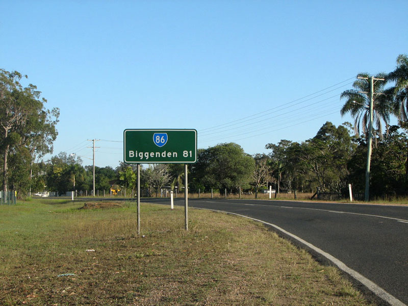
State Route 86 trailblazer facing westbound traffic, approximately 31km west of Maryborough. Photo taken: July 2008. |
 |
Recently reconstructed section of Maryborough-Biggenden Road, approximately 36km west of Maryborough. Photo taken: July 2008. |
 |
Maryborough-Biggenden Road looking west towards the level crossing of the Maryborough to Gayndah railway line (the 'Monto Loop Line'), 39km west of Maryborough. Photo taken: July 2008. |
 |
Maryborough-Biggenden Road looking west into the tiny village of Aramara, 41km west of Maryborough. Photo taken: July 2008. |
 |
Winding and undulating alignment, typical of this route, between Aramara and Brooweena. Photo taken: July 2008. |
 |
Dodgy AD sign westbound on Maryborough-Biggenden Road, approaching the tiny village of Broowena. This is where the road classification changes from Maryborough-Biggenden to Woolooga-Brooweena. Note that the sign incorrectly shows SR86 straight and right - it should have two separate panels. Photo taken: July 2008. |
 |
Looking west towards the sharp left-hand bend where the route turns south, 2.5km west of Brooweena/50km west of Maryborough. Photo taken: July 2008. |
 |
Looking southwest through the sharp southward curve, 50km west of Maryborough. Photo taken: July 2008. |
 |
Looking south across the Hayesmere Bridge over Munna Creek, 52km west of Maryborough. Photo taken: July 2008. |
 |
AD sign southbound approaching the turnoff to stay on the route towards Biggenden, 56km west of Maryborough. Continuing straight ahead takes motorists south to Woolooga. Photo taken: July 2008. |
 |
Surprisingly well AD sign northbound on Woolooga-Brooweena Road approaching the junction with State Route 86 near Boompa. I am unsure of the road names in this area - if you know of any reliable maps of the area, please drop me a line! Photo taken: July 2008. |
 |
Typically so-close-but-so-far AD sign eastbound on Maryborough-Biggenden Road approaching the Woolooga turnoff near Boompa. There's something just not quite right about the aesthetics of this sign. Photo taken: July 2008. |
 |
The last remaining single lane sections of this route are located between the Woolooga turnoff and the Fraser Coast Regional Council/North Burnett Regional Council boundary west of Boompa. This view is looking west just after the Woolooga turnoff, approaching the bridge over Sandy Creek. Photo taken: July 2008. |
 |
Looking northwest across the single-lane bridge over Sandy Creek, 57km west of Maryborough. Photo taken: July 2008. |
 |
Looking northwest across a two-lane bridge over Eel Creek, 1km west of Sandy Creek. Note the road narrows to a single-lane seal again after the bridge. Photo taken: July 2008. |
 |
Looking northwest towards the junction with Innooroolbar Road, 60km west of Maryborough. Photo taken: July 2008. |
 |
Low-level, single-lane section of the route, looking north approximately 61km west of Maryborough. Photo taken: July 2008. |
 |
Maryborough-Biggenden Road looking north towards the sharp westerly curve at Boompa, where the route regains its east-west orientation. Note the 'reduce speed' sign in the background. Photo taken: July 2008. |
 |
Maryborough-Biggenden Road looking north at the sharp westerly curve at Boompa. Photo taken: July 2008. |
 |
Maryborough-Biggenden Road looking west after the sharp curve at Boompa, showing the road again narrowing to a single-lane seal width. Photo taken: July 2008. |
 |
Maryborough-Biggenden Road looking west towards the Fraser Coast Regional Council/North Burnett Regional Council boundary and the railway level crossing between Boompa and Lakeside, 69km west of Maryborough. Photo taken: July 2008. |
 |
Maryborough-Biggenden Road looking west at the junction with Lower Lakeside Road, 73km west of Maryborough. Photo taken: July 2008. |
 |
Maryborough-Biggenden Road looking west approximately 75km west of Maryborough. Photo taken: July 2008. |
 |
Maryborough-Biggenden Road looking west towards the bridge over Degilbo Creek, 2km east of Biggenden. Photo taken: July 2008. |
 |
Maryborough-Biggenden Road looking west as you curve across Rollinson Creek into Biggenden. Photo taken: July 2008. |
 |
George Street looking northwest through Biggenden. Note the unusual centre parking. Photo taken: July 2008. |
 |
AD sign northwestbound on George Street approaching the junction with Isis Highway at Biggenden. This junction is the western terminus of State Route 86. Photo taken: July 2008. |
 |
George Street looking east from the junction with Isis Highway. Photo taken: July 2008. |
  |
ID signs at the junction of Isis Highway & George Street, Biggenden. Note the 'END' SR86 shield. Photos taken: July 2008. |
 |
AD sign southwestbound on Isis Highway approaching the staggered junctions with George Street & Edward Street, Biggenden. Photo taken: July 2008. |
 |
AD sign northeastbound on Isis Highway approaching the staggered junctions with George & Edward Streets. Note the symbol on the sign depicting the railway overbridge which can seen in the background. Photo taken: July 2008. |


Last updated 16 February 2012 © Ozroads 2003-2012. |