QUEENSLAND ALPHA-NUMERIC ROUTES
Example of alpha-numeric route marking signage on Ipswich Road at Buranda. Photo taken: December 2009.
Beginning in 2000, the Queensland Department of Main Roads (QMR) has been progressively introducing alpha-numeric route marking to directional signs across the state. However, whether the whole state will be converted to this style of alpha-numeric route marking is unknown and currently only the major regional highways and some former Metroads in South East Queensland have been re-badged as part of the changeover.
Planning for an alpha-numeric route marking system can be traced back to 1997, when all the States and Territories agreed to convert to alpha-numeric style route marking, in order to have a nationally consistent route marking scheme. Because the new system was primarily designed to aid the navigation of tourists (it is believed that a letter and number combination is more easily understood by tourists than a shielded system), QMR based its system around them. In 1999 the draft ‘Policy on Road Signing’ eventuated in the adoption of eight ‘Strategic Tourism Routes’ – the major road points of entry to Queensland and the main routes for the distribution of visitors within the State. The first eight routes were numbered from 1 to 9, curiously leaving out the number 8 (more on that later).
At completion of the massive Pacific Motorway construction project in September 2000, alpha-numeric signage made its debut in Queensland with route ‘M1’ appearing on directional signs on the Pacific Motorway between the Logan River and Pappas Way at Nerang. Soon afterwards the ‘M’ signs were extended south along the newly-named Pacific Motorway (formerly Highway) to Stewart Road at Tugun. Also trialed on the Pacific Motorway was the process of numbering exits, a successful venture that has resulted in the numbering of interchanges on the Pacific Motorway from Brisbane to Tugun.
The second alpha-numeric route, A2, is a National Highway and thus needed the agreement of the Queensland, Northern Territory and Commonwealth Governments before the re-numbering of the route could be approved. The re-badging of the route (was previously National Highways 54, 71 and 66) within Queensland was undertaken in May 2002 – the Year of the Outback. Many new signs were erected to advise motorists of the route marking change and they read:
Because the National Highway corridor, and thus route A2, bypasses Charleville, the major centre of South Western Queensland, an alternative route was introduced to link Charleville to the Strategic Tourism Routes. Alternative A2 splits from NH-A2 just west of Morven, following the Warrego Highway into Charleville and then the Mitchell Highway north to near Augathella. It was also signed during May 2002.
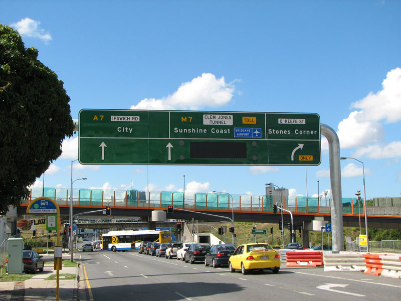
The introduction of more ‘Strategic Tourism Routes’ was undertaken at a steady pace, with A6 (Flinders Highway) the next cab off the rank, signed in 2003. Then followed A4 (Capricorn Highway), which was unfortunately fully converted by the time I got to travel on it in January 2005. Next came A7, which was done quite slowly from Charters Towers south to Roma. In January 2005, directional signs had been changed as far south as Capella and I have been advised that the changeover has since been completed as far as Roma. In May 2005 the conversion of Metroad 1 (Brisbane) and the Bruce Highway to become routes M1 and A1 was commenced and it has been reported that signage as far north as Cairns has been changed over. Also during 2005 came the introduction of A5 (Leichhardt Highway from Gore Hwy junction to Dululu) and A3 (Cunningham Hwy to Dululu via Toowoomba, Yarraman and the former NR17).
The introduction of those final four routes in 2005 just about completed QMR’s Strategic Tourism Routes plan. Well, not quite. The eighth route in the plan was to be A9 – the Mitchell Highway from Charleville south to Barringun. Thankfully commonsense prevailed and, probably after some consultation with the route marking planners at the RTA (NSW), this number was changed to A71, thus providing a continuous route number from Nyngan to Charleville.
Other proposed Strategic Tourism Routes have also been altered following consultation (presumably) with the RTA (NSW) and DOTARS (Commonwealth). Route A3 was originally intended to extend from its current terminus at the Cunningham Highway north of Warwick to the NSW Border at Wallangarra, however this has been changed so that route A15 is continuous from Hexham (NSW) to Brisbane, as National Highway 15 is now. Route A7 was originally intended to extend south from Roma to Hebel, via St George and Dirranbandi, but the section south of Hebel is now A55, consistent with the RTA’s decision to sign route B55 on its section of the Castlereagh Highway.
“But what about route A8?” you are probably wondering. Well, my theory is that it will may be applied, sometime in the future, to the east-west leg of Highway One – from the NT Border near Wollogorang across the Gulf country to Cairns. Of course, for that route to be signed as A8 it would firstly have to be sealed, probably to a two-lane standard (much of the Gulf Developmental Road is a one-lane seal). Then there may also be issues with stopping the Highway One ring around the edge of Australia, but it could be done.
A further thrust of conversions occurred in 2008, with a number of Brisbane routes changed over, including M2, M3/A3, M5/A5 and A7. Unfortunately the DMR, in their wisdom, has used duplicate numbers which makes things very confusing. Route M5/A5 is the Centenary Highway in Brisbane, as well as being the Leichhardt Highway in southern and central Queensland! Probably the worst example is route M3/A3 being duplicated only about 120km apart. It is disappointing to see that there is apparently nobody steering the ship at Main Roads and yet another route marking system has been implemented with zero thought and conviction. What a waste of money!
List of alpha-numeric routes in Queensland
Due to the duplication of numbers I have included region locations for some routes to distinguish between two different routes with the same number
Pacific & Gateway Motorways, Bruce Highway |
|
Brisbane to NT Border via Gateway, Logan & Ipswich Motorways and Warrego, Landsborough and Barkly Highways
|
|
Charleville Alternative route to National Highway A2, servicing Charleville via Warrego and Mitchell Highways |
|
Winton Alternative route to National Highway A2 through Winton town centre |
|
Brisbane Pacific Motorway, Inner City Bypass, Lutwyche Road, Gympie Road |
|
| Southern and Central Queensland | |
Brisbane Port of Brisbane Motorway (replaced SR42) |
|
Central Queensland Capricorn Highway (replaced NR66) |
|
Brisbane Cetenary Motorway & Centenary Highway (replaced Metroad 5) |
|
Southern and Central Queensland Leichhardt Highway (replaced NR39) |
|
Northern Queensland Flinders Highway |
|
| Brisbane | |
Southern and Central Queensland Roma-Charters Towers via former NR55 |
|
Brisbane Cunningham Highway (Warrego Highway to Redbank Plains Road) |
|
Southern Queensland Gore Highway (Toowoomba to Toowoomba Regional Council/Goondiwindi Regional Council boundary) |
|
Southern Queensland Castlereagh & Carnarvon Highways (Hebel-Roma) |
|
Southern Queensland Mitchell Highway (Charleville to NSW Border) |
Last updated 9 November 2012 © Ozroads 2003-2012. |