National Route 80 Buchanan Highway |
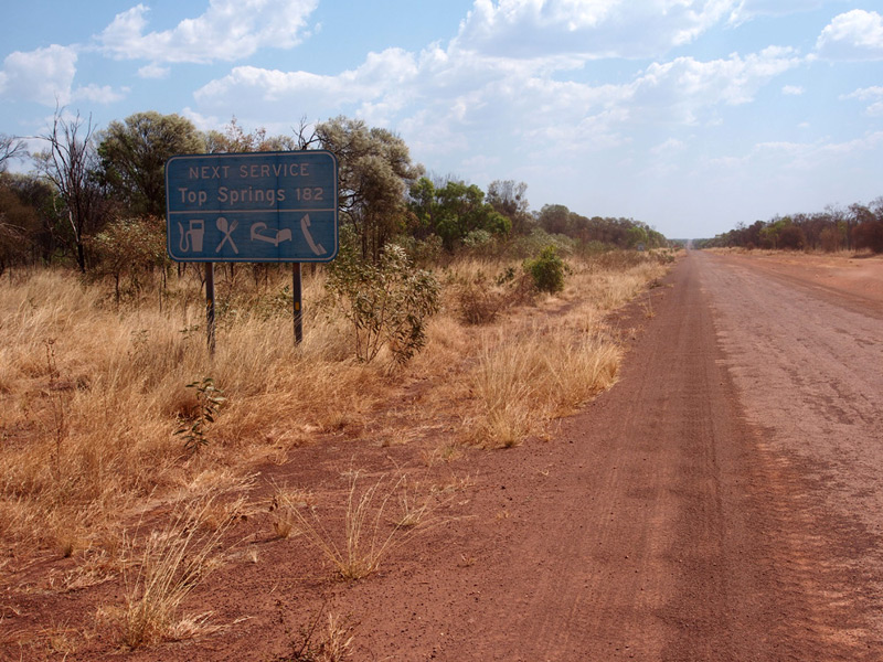
Deteriorating services sign westbound on Buchanan Highway, west of the Stuart Highway junction. Source: Peter Renshaw, September 2014.
National Route 80 introduced: c1989
Length: 392km
Eastern Terminus: Stuart Highway, 8km north of Dunmarra
Western Terminus: Victoria Highway, 29km SE of Timber Creek
Route taken: From the Stuart Highway near Dunmarra, west via Top Springs and Victoria River Downs, to the Victoria Highway near Timber Creek
Duplexes: Nil
Focal Points: 'To Stuart Hwy', Top Springs, (Timber Creek)
Notable Events:
2 Nov 1966 - Buchanan Highway officially named (Stuart Highway - Top Springs - Wave Hill - WA Border)
9 Oct 1996 - Section from Top Springs to NT Border renamed Buntine Highway; Buchanan Highway reproclaimed to extend from Stuart Highway to Victoria Highway via Top Springs and Victoria River Downs
History:
The Buchanan Highway can trace it roots back to the late 1800s when Nathaniel (‘Nat’) Buchanan and Sam Croker first overlanded cattle from western Queensland to the Victoria River district and eastern Kimberley. With the discovery of sufficient water along this route it was established as the Murranji Stock Route in 1886 and was used by men travelling to the Kimberley Gold Rush (1885-1886). As a stock route, the Murranji was hard going, with unreliable water supplies in the dry season, lancewood and bulwaddy thickets, and sections of 'drummy' ground which would spook cattle and make them difficult to control. in the 1960s the Australian Government invested significantly in the construction of roads across the Kimberley, Northern Territory and Western Queensland cattle country to aid the beef industry. As part of this program, a gravel 'beef road' was constructed largely along a new alignment from the Stuart Highway 8km north of Dunmarra, through Top Springs, to Victoria River Downs. This road is now known as the Bunchanan Highway.
The original droving track left the Stuart Highway at Newcastle Waters, approximately 80km south of Dunmarra, following Buckett Creek before turning north west. The routes of the Murranji and the modern Buchanan Highway converge north west of Murranji Waterhole and proceed generally parallel to each outher to Top Springs. The highway alignment westward from the Stuart Highway was located to avoid a large area of flooded country during the wet seasons and provide a more convenient connection to the Carpentaria Highway.
In 1966, the name Buchanan Highway was given to the route from the Stuart Highway near Dunmarra to Top Springs, then southwest to Wave Hill and onwards the Western Australian Border near Nicholson. The name was chosen in recognition of Nat Buchanan's role in pioneering the beef industry and cattle droving in the Northern Territory. The road from Top Springs via Victoria River Downs to Timber Creek was simply known as 'Victoria River Downs Road'.
|
Photos of National Route 80 / Buchanan Highway - Stuart Highway to Top Springs |
|
  |
Standard AD sign (top) and Savannah Way tourist sign (bottom), northbound on Stuart Highway (NHR87) approaching the junction with Buchanan Highway (NR80), 8km north of Dunmarra. Source: Peter Renshaw, September 2014. |
  |
Old and new iterations of the southbound AD sign on Stuart Highway (NHR87) approaching Buchanan Highway (NR80), 8km north of Dunmarra. I wouldn't say either sign was particularly well-designed but at least the top sign could be read properly at 110km/h. Top photo: NT Government, July 2004. Bottom photo: Peter Renshaw, September 2014. |
   |
Old and new ID sign assemblies at the junction of Stuart Highway (NHR87) & Buchanan Highway (NR80), 8km north of Dunmarra. Note the incorrect omission of NR80 route markers on both Buchanan Highway ID signs. Top photo: NT Government, July 2004. Middle & bottom photos: Peter Renshaw, September 2014. |
 |
AD sign eastbound on Buchanan Highway (NR80) approaching the junction with Stuart Highway (NHR87), 8km north of Dunmarra. Note the washed out route marker shields - apparently a common problem with the method of manufacture of this type of sign. Source: Peter Renshaw, September 2014. |
 |
Buchanan Highway (NR80) looking west from the junction with Stuart Highway (NHR87), showing standard NT road closure signage. Source: Peter Renshaw, September 2014. |
 |
Buchanan Highway (NR80) looking east towards the junction with Stuart Highway (NHR87). Source: Peter Renshaw, September 2014. |
 |
Westbound RD sign on Buchanan Highway (NR80) approximately 500m west of Stuart Highway (NHR87). The roadhouse at Top Springs is the only settlement to speak of along this highway; Timber Creek being located on the Victoria Highway approximately 30km past the end of the Buchanan. Source: Peter Renshaw, September 2014. |
 |
Deteriorating services signage westbound on Buchanan Highway (NR80) approximately 800m west of Stuart Highway (NHR87). Source: Peter Renshaw, September 2014. |
  |
Two westbound views between 1km and 3km west of Stuart Highway showing typical outback NT warning signage and typical road conditions. The sign in the second photo reads 'Unfenced Road, Beware Wandering Stock'. Source: Peter Renshaw, September 2014. |
 |
Typical view west approximately 5km west of Stuart Highway / 177km east of Top Springs. Source: Peter Renshaw, September 2014. |
 |
Another typical view west approximately 25km west of Stuart Highway / 157km east of Top Springs. If Peter was to use one word to describe his journey across the Buchanan, it would be 'corrugated'. Source: Peter Renshaw, September 2014. |
 |
View west along the corrugations, approximately 30km west of Stuart Highway / 150km east of Top Springs. The turnoff to Buchanan Downs station is in the background. Source: Peter Renshaw, September 2014. |
 |
View west at the turnoff to Buchanan Downs cattle station, 30km west of Stuart Highway / 150km east of Top Springs. Source: Peter Renshaw, September 2014. |
 |
Two rather large pieces of road kill, heading west on the Buchanan Highway approximately 42km west of Stuart Highway. Source: Peter Renshaw, September 2014. |
 |
View west at the turnoff to Hidden Valley cattle station, 53km west of Stuart Highway. |
 |
Typical kilometre plate facing eastbound traffic, 60km west of Stuart Highway / 130km east of Top Springs. |
 |
View east from the same spot, 60km west of Stuart Highway / 130km east of Top Springs. |
 |
Long view west towards the level crossing of the Alice Springs - Darwin railway, 63km west of Stuart Highway. |
 |
View west through the level crossing of the Alice Springs - Darwin railway, complete with sealed surface, linemarking and flashing light control. Source: Peter Renshaw, September 2014. |
 |
A view east towards the level crossing at 63km west of Stuart Highway - look at those corrugations. Source: Peter Renshaw, September 2014. |
 |
More corrugations - an easterly view approximately 70km west of Stuart Highway. Source: Peter Renshaw, September 2014. |
 |
View west, 82km west of Stuart Highway / 100km east of Top Springs. Source: Peter Renshaw, September 2014. |
 |
View east, 90km west of Stuart Highway, with a missing kilometre plate. Source: Peter Renshaw, September 2014. |
 |
View east, 100km west of Stuart Highway. This could almost be the same spot as the above photo - not much variation to the scenery in these parts. Source: Peter Renshaw, September 2014. |
 |
View east towards a cattle grid at approximately 115km west of Stuart Highway. This is probably the boundary of Murranji and Dungowan cattle stations. Source: Peter Renshaw, September 2014. |
 |
View west from the same location with another warning about the road being unfenced. Source: Peter Renshaw, September 2014. |
  |
Views west and east at the turnoff to Dungowan station homestead, 125km west of Stuart Highway / 57km east of Top Springs. Source: Peter Renshaw, September 2014. |
  |
Views east and west, 140km west of Stuart Highway / 42km west of Top Springs. This sign marks the spot where a tye change was required for Peter's subaru, thanks to the rough-as-guts surface of the Buchanan. Source: Peter Renshaw, September 2014. |
  |
Views east and west, approximately 142km west of Stuart Highway. The Buchanan passes through a series of low hills adjacent to the Armstrong River which is a nice break from a very straight and flat stretch of 140km. Source: Peter Renshaw, September 2014. |
  |
East and west views at the Armstrong River floodway, 147km west of Stuart Highway / 35km east of Top Springs. Source: Peter Renshaw, September 2014. |
 |
Long view east towards the Armstrong River floodway, 147km west of Stuart Highway / 35km east of Top Springs. Source: Peter Renshaw, September 2014. |
 |
View west, 30km east of Top Springs. Source: Peter Renshaw, September 2014. |
 |
Passing through a herd of cattle approximately 25km east of Top Springs, in the vicinity of Old Top Springs station. Source: Peter Renshaw, September 2014. |
  |
Two westerly views across the single-lane bridge at Illawarra Creek, 10km east of Top Springs. The bridge superstructure was replaced in 2011 to remove a load limit. Source: Peter Renshaw, September 2014. |
 |
A long view easterly towards the Illawarra Creek bridge, 10km east of Top Springs. Source: Peter Renshaw, September 2014. |
 |
A short sealed section across a floodway, complete with abandoned vehicle. Approximately 9km east of Top Springs. Source: Peter Renshaw, September 2014. |
 |
A view west approximately 7km east of Top Springs. Source: Peter Renshaw, September 2014. |
 |
Kilometre plate showing 180km to Stuart Highway, looking east with a floodway in the background, 2km east of Top Springs. Source: Peter Renshaw, September 2014. |
 |
Typical outback NT warning / advisory signage heading east out of Top Springs. Source: Peter Renshaw, September 2014. |
Signage facing eastbound drivers on the Buchanan Highway (NR80) as they leave Top Springs. Note the erroneous National Route 11 shield (no idea where that came from) and the less-than-helpful focal point of 'To Stuart Highway'. Dunmarra (note the spelling mistake on the sign in the bottom photo) might have been more helpful given it is the location of the next services. Also note the road closure gates in the background of the first photo. Source: Peter Renshaw, September 2014. |
|
  |
Non-standard AD sign and Savannah Way tourist sign, westbound on Buchanan Highway (NR80) approaching the junction with Buntine Highway (NR96) at Top Springs. Note the general poor design of the AD sign, including the incorrect route shields - these should of course be National Route shields rather than State Route shields. Also note the sealed surface. Source: Peter Renshaw, September 2014. |
 |
View west approaching the junction at Top Springs, with appropriate locality marker. Source: Peter Renshaw, September 2014. |
 |
Non-standard fingerboard signage the junction of the Buchanan Highway (NR80) & Buntine Highway (NR96), Top Springs. The Buntine Highway extends south west from Top Springs to the WA Border, east of Halls Creek, where motorists can join the Duncan Road to continue west to Halls Creek. Prior to the naming of Buntine Highway in 1996, the Buchanan Highway and NR80 used to turn south west at Top Springs and follow what is now the Buntine Highway. Source: Peter Renshaw, September 2014. |
  |
Daytime and sunrise views of Top Springs roadhouse, located at the junction of the Buchanan & Buntine Highways. Source: Peter Renshaw, September 2014. |
  |
Northbound and southbound Advance Direction signs on Buntine Highway (NR96) approaching the junction with Buchanan Highway (NR80) at Top Springs. Again note the poor design and incorrect route markers. The Buntine Highway carries more traffic than the Buchanan and is accordingly a pretty reasonable two-lane sealed highway in the vicinity of Top Springs. Source: Peter Renshaw, September 2014. |
  |
Easstbound Advance Direction and Savannah Way signage on Buchanan Highway (NR80) approaching the junction with Buntine Highway (NR96) at Top Springs. This time, instead of incorrect route markers, we get no route markers! Source: Peter Renshaw, September 2014. |
 |
Westbound RD sign on Buchanan Highway (NR80) as you leave Top Springs. A rare sight at Top Springs - a sign with the correct route number! Source: Peter Renshaw, September 2014. |


Photos of National Route 80 / Buchanan Highway - Top Springs to Victoria Highway |
|
 |
View east approximately 20km west of Top Springs. Source: Peter Renshaw, September 2014. |
 |
View west from the same spot, with a hazy sunset among the termite mounds. Source: Peter Renshaw, September 2014. |
 |
View east at the turnoff to Moolooloo, an outstation within the giant Victoria River Downs pastoral lease, approximately 35km west of Top Springs. Source: Peter Renshaw, September 2014. |
 |
View east towards the short concrete floodway at Sandy Creek, 65km west of Top Springs. Many of the floodways along this section of the highway were unsealed, with treacherous and unpredictable holes at the bottom, slowing travel down significantly. Source: Peter Renshaw, September 2014. |
 |
View east towards an unnamed floodway, approximately 70km west of Top Springs. Many of the floodways along this section of the highway were unsealed, with treacherous and unpredictable holes at the bottom, slowing travel down significantly. Source: Peter Renshaw, September 2014. |
 |
View east showing typical road conditions between 70 and 85km west of Top Springs. Source: Peter Renshaw, September 2014. |
  |
Two views of the Buchanan Highway crossing the Victoria River at Dashwood Crossing, 85km west of Top Springs. As you can see, this crossing is flooded regularly in 'the Wet'. Source: Peter Renshaw, September 2014. |
 |
Dashwood Crossing sign, eastbound on Buchanan Highway as you approaching the Victoria River, 85km west of Top Springs. Source: Peter Renshaw, September 2014. |
 |
Sandy / bulldust surface looking east to the floodway at Crawford Creek, approximately 88km west of Top Springs. Source: Peter Renshaw, September 2014. |
 |
Looking west approaching a short sealed section past the Victoria River Downs homestead, approximately 99km west of Top Springs. Victoria River Downs is one of the more well-known cattle stations in the NT, with historical connections to Nat Buchanan (after whom this highway is named) and Sidney Kidman. Source: Peter Renshaw, September 2014. |
 |
View east back towards the Victoria River Downs homestead, with 'Top Springs 100' kilometre plate. Source: Peter Renshaw, September 2014. |
 |
View south-east from the Yarralin / Humbert River turnoff, 101km west of Top Springs. Source: Peter Renshaw, September 2014. |
 |
Typical NT tourist signage, north-westbound on Buchanan Highway approaching the Yarralin / Humbert River turnoff, 101km west of Top Springs. This road serves the Humbert River cattle station, the aboriginal communities of Yarralin and Lingara, and as a popular remote 4WD access to the Gregory National Park. Source: Peter Renshaw, September 2014. |
 |
Signage assembly at the Yarralin / Humbert River turnoff. Note the 'Binns Track' sign - this seems to be a tourist route from near Alice Springs to Timber Creek, incorporating part of the Buchanan Highway and the Humbert River access to Gregory Natioal Park. Source: Peter Renshaw, September 2014. |
 |
View south-eastbound on Buchanan Highway towards the Yarralin / Humbert River turnoff, 101km west of Top Springs. Source: Peter Renshaw, September 2014. |
 |
View south on Buchanan Highway, 130km north west of Top Springs. Source: Peter Renshaw, September 2014. |
 |
Looking south at the entrance to Kidman Springs (Victoria River Research Station), 136km north west of Top Springs. Source: Peter Renshaw, September 2014. |
 |
Looking south 140km north west of Top Springs. Source: Peter Renshaw, September 2014. |
 |
View south towards the single-lane bridge across Surprise Creek, 143km north west of Top Springs. Peter remarks that the best surprise was the short length of sealed pavement which offered some respite from the incessant corrugations. Source: Peter Renshaw, September 2014. |
 |
View south east towards what is probably Sundown Hill in the background, approximately 148km north west of Top Springs. Source: Peter Renshaw, September 2014. |
  |
View east and west showing back-to-back kilometre plates 150km north west of Top Springs. Note that 'VH' for Victoria Highway is prerferred over Timber Creek for north-westbound traffic. Source: Peter Renshaw, September 2014. |
 |
Crocodile warning signage facing north-westbound traffic as you approach Jasper Gorge. There are several pools of mostly-permanent water within the gorge but the risk of crocodiles is ever present in the top end of the NT. Source: Peter Renshaw, September 2014. |
 |
View east at the eastern end of Jasper Gorge, approximately 155km north west of Top Springs. Source: Peter Renshaw, September 2014. |
  |
Easterly views showing typical conditions through the eastern end of Jasper Gorge, approximately 157km north west of Top Springs. Source: Peter Renshaw, September 2014. |
   |
One westerly and two easterly views at the bridge over Jasper Creek in Jasper Gorge, 158km north west of Top Springs. Source: Peter Renshaw, September 2014. |
 |
View east towards Jasper Gorge at approximately 165km north west of Top Springs. Source: Peter Renshaw, September 2014. |
 |
View wesst across the floodway at Charlies Crossing, approximately 166km north west of Top Springs. Source: Peter Renshaw, September 2014. |
 |
Apparently one of the better sections of the Buchanan Highway surface - view west near Charlies Crossing approximately 166km north west of Top Springs. Source: Peter Renshaw, September 2014. |
 |
Long view south-east through the western end of Jasper Gorge, approximately 167km north west of Top Springs. Source: Peter Renshaw, September 2014. |
 |
Another easterly view on the approach to Jasper Gorge, approximately 168km north west of Top Springs. Source: Peter Renshaw, September 2014. |
 |
Looking east across the floodway at Six Mile Creek, approximately 168km north west of Top Springs. Source: Peter Renshaw, September 2014. |
 |
View south approximately 169km north west of Top Springs. Source: Peter Renshaw, September 2014. |
 |
View north-west at the floodway across Slatey Creek, approximately 169km north west of Top Springs. Source: Peter Renshaw, September 2014. |
  |
Back-to-back kilometres plates at 170km north west of Top Springs / 40km south of Victoria Highway. Source: Peter Renshaw, September 2014. |
 |
General roadscape looking south approximately 171km north west of Top Springs / 39km south of Victoria Highway. Source: Peter Renshaw, September 2014. |
 |
Second crossing of Slatey Creek, this time with a much smoother sealed floodway, approximately 173km north west of Top Springs. Source: Peter Renshaw, September 2014. |
 |
Looking south to the floodway at Eugene Creek, approximately 174km north west of Top Springs. Source: Peter Renshaw, September 2014. |
 |
Another floodway, this time unnamed, approximately 175km north west of Top Springs. Source: Peter Renshaw, September 2014. |
 |
Brown fingerboard sign at the turnoff for Tuwakan 4WD Track, 176km north west of Top Springs / 34km south of Victoria Highway. Source: Peter Renshaw, September 2014. |
  |
Back-to-back kilometre plates 180km north west of Top Springs / 30km south of Victoria Highway. Source: Peter Renshaw, September 2014. |
 |
View north across the single-lane bridge at Skull Creek, 14km south of Victoria Highway. Source: Peter Renshaw, September 2014. |
 |
Long view south towards Skull Creek, 14km south of Victoria Highway. Source: Peter Renshaw, September 2014. |
Northerly and southerly views, approximately 3-4km south of Victoria Highway. The last 10km or so of the Buchanan Highway consists of a series of sweeping bends. Source: Peter Renshaw, September 2014. |
|
 |
Slightly dodgy AD sign northbound on Buchanan Highway (NR80) approaching the junction with Victoria Highway (NHR1), 210km north west of Top Springs. At least we have the correct route marker at this junction! Source: Peter Renshaw, September 2014. |
  |
Typical Reassurance Distance and services signs southbound on Buchanan Highway (NR80) near the junction with Victoria Highway (NHR1). Note that the distance to Top Springs on these signs (212km) disagrees with the back-to-back kilometre plates in previous photos which suggested a distance of 210km. Also note the inclusion of Dunmarra on this sign, spelled incorrectly as 'Dunmurra'. Photos taken: October 2015. |
 |
Buchanan Highway (NR80) looking south from the junction with Victoria Highway (NHR1), showing standard NT road closure signage. Source: Peter Renshaw, September 2014. |
Intersection Direction sign assemblies at the junction of Victoria Highway (NHR1) & Buchanan Highway (NR80), 29km east of Timber Creek. Top photo: October 2015. Middle & bottom photos: Peter Renshaw, September 2014. |
|
  |
Typical Advance Direction and Savannah Way tourist signs, eastbound on Victoria Highway (NHR1) approaching the junction with Buchanan Highway (NR80), 29km east of Timber Creek. Note the missing NR80 route marker. Top photo: October 2015. Bottom photo: Peter Renshaw, September 2014. |
  |
Typical Advance Direction and Savannah Way tourist signs, westbound on Victoria Highway (NHR1) approaching the junction with Buchanan Highway (NR80), 29km east of Timber Creek. Note the missing NR80 route marker. Top photo: October 2015. Bottom photo: Peter Renshaw, September 2014. |


Last updated 21 July 2018. © Ozroads 2003-2018. |