NSW Route B72 Snowy Mountains Highway |
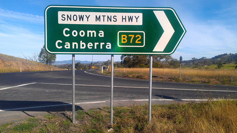
ID sign marking the beginning of route B72 at the junction of Princes Highway & Snowy Mountains Highway, 7km north of Bega.
Source: Daniel Thornton, June 2013.
Introduced: April 2013
Replaced: National Route 18
Length: 332km
Eastern Terminus: Princes Highway & Snowy Mountains Highway, 7km north of Bega
Western Terminus: Hume Highway & Snowy Mountains Highway, 13km south west of Tumblong
Route taken: Snowy Mountains Highway, Monaro Highway, Snowy Mountains Highway
Focal Points: Bega, Cooma, (Canberra), Tumut, Adelong, (Wagga Wagga)
Roads Act 1993 classification: Highway No. 4 (Snowy Mountains Highway), Highway No. 19 (Monaro Highway)
Notable Events:
February 2006 - first uncovered B72 is photographed at Gilmore
September 2012 - Alpha-numeric route marking scheme announced by RMS
April 2013 - route B72 fully signposted
Description:
Coming soon...
History:
Coming soon...
Signage:
Coming soon...
|
Photos of route B72 - Bega to Tumblong |
|
ID sign marking the beginning of route B72 at the junction of Princes Highway & Snowy Mountains Highway, 7km north of Bega. Source: Daniel Thornton, June 2013. |
|
 |
AD sign southbound on Monaro Highway (Sharp Street) approaching the junction with Snowy Mountains Highway, Cooma. Note the B72 route marker is missing for the left turn. Photo taken: July 2013. |
 |
AD sign northeast bound on Snowy Mountains Highway (Sharp Street) approaching the junction with Monaro Highway (Sharp Street & Bombala Street), Cooma. Note the missing National Route 23 shield for the right turn - I wonder if RMS will omit a B23 route marker as well when B23 is unveiled? Photo taken: July 2013. |
 |
Coverplated RD sign westbound on Snowy Mountains Highway on the western outskirts of Cooma. Source: Craig Crompton, July 2013. |
 |
RD sign eastbound on Snowy Mountains Highway after the junction with Kosciuszko Road, 6km west of Cooma. Photo taken: July 2013. |
 |
ID sign pointing northwest bound at the junction of Snowy Mountains Highway & Kosciuszko Road, 7km west of Cooma. Photo taken: July 2013. |
 |
Looking into the sun, northbound on Snowy Mountains Highway approaching the junction with Middlingbank Road, 28km west of Cooma. Photo taken: July 2013. |
 |
RD sign eastbound on Snowy Mountains Highway as you leave Adaminaby. Photo taken: July 2013. |
 |
Frost-affected RD sign eastbound on Snowy Mountains Highway after the junction with Link Road at Kiandra. Source: Craig Crompton, July 2013. |
 |
AD sign eastbound on Link Road approaching the junction with Snowy Mountains Highway, Kiandra. This sign replaced an old black AD sign which omitted the NR18 route marker - a rare example of an old black sign surviving until the introduction of alpha-numeric route marking. Source: Craig Crompton, July 2013. |
 |
ID sign at the junction of Snowy Mountains Highway & Link Road, Kiandra. Source: Craig Crompton, July 2013. |
 |
RD sign westbound on Snowy Mountains Highway after the junction with Link Road, Kiandra. Source: Craig Crompton, July 2013. |
 |
RD sign westbound on Snowy Mountains Highway after the junction with Yarrangobilly Caves Road, 3km south of Rules Point. Source: Craig Crompton, July 2013. |
 |
Prematurely uncovered B72 route marker on a fingerboard sign at the junction of Snowy Mountains Highway & Long Plain Road, Rules Point. Source: Richard Wardle, June 2012. |
 |
Lovely snow-covered view of the Snowy Mountains Highway as it descends eastward towards Rules Point. Source: Craig Crompton, July 2013. |
 |
Looking west from the same location, showing a rather bizarre non-standard sign replacing the former standard 'Merge Right' sign. Source: Craig Crompton, July 2013. |
 |
Prematurely uncovered B72 route marker on a fingerboard sign at the junction of Snowy Mountains Highway & Jounama Dam Road, Talbingo. Source: Rob Tilley, November 2010. |
 |
Prematurely uncovered B72 route marker on an ID sign at the junction of Snowy Mountains Highway, Gocup Road & Capper Street, Tumut. Note the National Route 18 shield still covering one of the B72 route markers. Source: Kyle Threlfo, June 2012. |
 |
Prematurely uncovered B72 route marker on an RD sign westbound on Snowy Mountains Highway on the western outskirts of Tumut. Source: Richard Wardle, October 2008. |
 |
Prematurely uncovered B72 route marker on an AD sign eastbound on Snowy Mountains Highway approaching Batlow Road, Gilmore. This was the first uncovered B72 route marker to be spotted. Photo taken: April 2010. |
 |
ID sign at the junction of Snowy Mountains Highway & Tumut Street, Adelong. Source: Richard Wardle, October 2008. |