NSW Route B58 Riverina Highway |
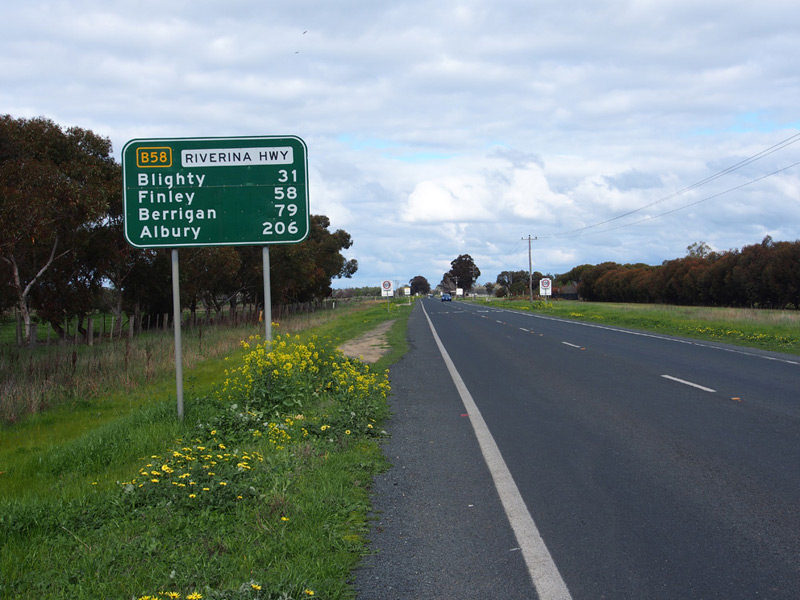
RD sign eastbound on Riverina Highway as you leave Deniliquin. Source: Peter Renshaw, August 2013.
Introduced: August 2013
Replaced: National Route 58
Length: 204km
Eastern Terminus: Hume Highway & Riverina Highway, East Albury
Western Terminus: Cobb Highway & Riverina Highway, Deniliquin
Route taken: Riverina Highway (including Finley Road through Deniliquin; Tuppal Street, Murray Street & Berrigan Road through Finley; Chanter Street & Jerilderie Street through Berrigan; Sturt Street & Hawkins Street through Howlong; and Padman Drive, Wodonga Place, Hume Street, Young Street & Guinea Street through Albury)
Focal Points: Denilqiuin, Finley, Berrigan, (Corowa), Albury, Lake Hume
Roads Act 1993 classification: Highway No. 20 (Riverina Highway), Highway No. 17 (short section of Newell Highway through Finley)
Notable Events:
September 2004 - first coverplated B58 sign spotted east of Albury
January 2005 - first uncovered B58 sign spotted between Deniliquin and Finley
September 2012 - Alpha-numeric route marking scheme announced by RMS
August 2013 - route B58 signposted
Description:
Route B58 is an east-west route across the southern Riverina region, following the Riverina Highway. It directly replaces the former National Route 58, with the exception that B58 terminates at the Hume Highway junction in East Albury rather than extending to Lake Hume as National Route 58 did.
History:
Coming soon...
Signage:
A coverplated B58 route marker was erected east of Albury in 2004. The first exposed B58 route markers were spotted in January 2005 in Deniliquin, including a dodgy gold-bordered route marker. Further B58 route numbers were left uncovered at the junction with the Hume Highway in 2007, whilst a large number of sign replacements through Albury were also undertaken at the same time but coverplated with National Route 58 route markers.
|
Photos of route B58 - Deniliquin to Berrigan |
|
 |
AD sign northbound on Cobb Highway (Davidson Street) approaching the junction with Riverina Highway (Finley Road), Deniliquin. Source: Peter Renshaw, August 2013. |
 |
AD sign southeastbound on Cobb Highway (Hay Road) approaching the junction with Riverina Highway (Finley Road), Deniliquin. Source: Peter Renshaw, August 2013. |
 |
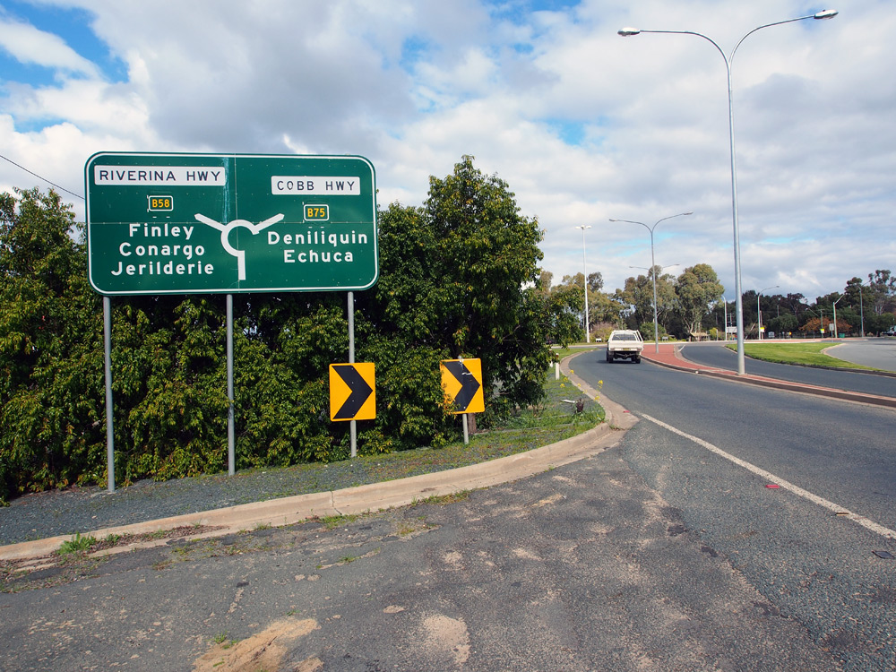
ID sign facing northbound traffic at the junction of Cobb & Riverina Highways, Deniliquin. Source: Peter Renshaw, August 2013. |
  |
AD sign eastbound on Riverina Highway (Finley Road) approaching the junction with Wanderer Street, Deniliquin. Note that the B58 route marker is on a sticker rather than an aluminium coverplate. Source: Peter Renshaw, August 2013. |
 |
ID sign assembly at the junction of Riverina Highway (Finley Road) & Wanderer Street, Deniliquin. Source: Peter Renshaw, August 2013. |
 |
AD sign westbound on Riverina Highway (Finley Road) approaching the junctions with Cobb Highway and Wanderer Street, Deniliquin. Source: Peter Renshaw, August 2013. |
  |
RD sign eastbound on Riverina Highway (Finley Road) as you leave Deniliquin. The first photo shows the dodgy coverplate installed after 2005 and retained until the route was unveiled in August 2013. Note the dodgy route marker using gold rather than yellow and white. Top photo: Peter Renshaw, June 2012. Source: Peter Renshaw, August 2013. |
 |
Prematurely uncovered B58 fingerboard sign at the junction of Riverina Highway & Coree Road, 44km east of Deniliquin. Source: Peter Renshaw, November 2012. |
Photos of B58 - Berrigan to Howlong |
|
 |
Prematurely uncovered B58 ID sign at the junction of Riverina Highway & Honor Avenue, 6km north of Corowa. Source: Rick Wardle, December 2008. |
 |
Prematurely uncovered B58 ID sign at the junction of Riverina Highway & Honor Avenue, 6km north of Corowa. Source: Rick Wardle, December 2008. |
Photos of B58 - Howlong to East Albury |
|
 |
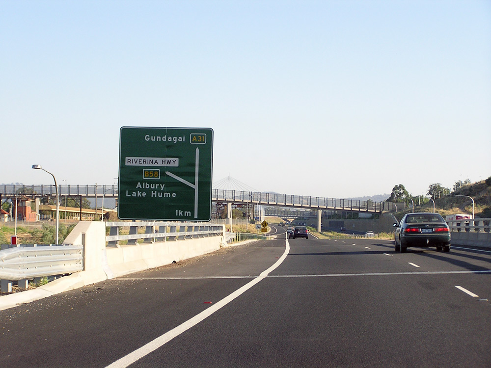
Diagrammatic AD sign eastbound on Riverina Highway (Guinea Street) approaching the junction with Hume Highway at East Albury. This is the eastern terminus of B58. Photo taken: July 2007. |
  |
ID signs at the junction of Hume Highway & Riverina Highway, East Albury. Photos taken: July 2007. |
     |
Series of B58 signs southbound on Hume Highway approaching the junction with Riverina Highway, East Albury. Note the final sign incorrectly shows B58 going both ways. Photos taken: July 2007. |
   |
Series of B58 signs northbound on Hume Highway approaching the junction with Riverina Highway, East Albury. Photos taken: July 2007. |
 |
AD sign westbound on Riverina Highway approaching the junction with Hume Highway, East Albury. Note the missing B58 route marker. Photo taken: July 2007. |
B58 east of Albury?
Prior to the official announcement regarding alpha-numeric routes in September 2012, several signs were erected along Riverina Highway between Albury and Bethanga Bridge which indicated that route B58 would extend east of Albury. Presumably this would have involved following Riverina Highway to its terminus at the NSW/Victoria State Border at Bethanga Bridge.
Photos of B58 - Albury to Bethanga Bridge |
|
 |
AD sign on the southbound off-ramp from Hume Highway to Riverina Highway, East Albury, showing B58 continuing east of Albury. Photo taken: July 2007. |
 |
ID sign facing the southbound off-ramp from Hume Highway to Riverina Highway, East Albury, showing B58 continuing east of Albury. Photo taken: July 2007. |
 |
ID sign facing the northbound off-ramp from Hume Highway to Riverina Highway, East Albury, showing B58 continuing east of Albury. Photo taken: July 2007. |
 |
Dodgy fingerboard sign at the junction of Riverina Highway & Elizabeth Mitchell Drive, 5km east of Albury, with a B58 route marker located beneath the National Route 58 coverplate. Photo taken: Viseth Uch, September 2004. |
Last updated 1 November 2013 © Ozroads 2003-2013. |