Gwydir Highway: History and Development |
The Gwydir Highway is a vital east-west artery connecting the coast with the New England tablelands and the western plains. Running perpendicular to the three northern New South Wales railway lines the route of the highway became an established road long before the advent of the car. Today, the highway carries the National Route 38 shield for its entire length - between the Pacific Highway at South Grafton and the Castlereagh Highway north of Walgett. The road that would later become the Gwydir Highway was first constructed and improved in 1867 at the request of the Commissioner and Engineer for Roads in New South Wales who considered that “a good road via Newton Boyd, if the difficulties were not too great, would be the proper to adopt as a main road.”1 The following year the road was opened to full traffic and a steam ferry was established across the Clarence River between South Grafton and Grafton, completing the link. Further construction continued over the next ten years to bring the road up to standard and bridges were opened across the Orara River (1874), the Nymboida River (1875) and the Mann River (1877). The newly-formed Main Roads Board declared the roads between South Grafton , Newton Boyd, Glen Innes, Inverell, Moree and Collarenebri State Highway No. 12 on 7 August 1928 . State Highway No. 12 was named Gwydir Highway after the Gwydir River which the highway follows between Gravesend and Collarenebri. Initially the western terminus was located at a steam ferry across the Barwon River , eleven miles north of Collarenebri but a bridge over the Barwon River was constructed at Collarenebri during the 1930s and the highway was realigned to terminate at the western end of the bridge. The first improvement effected by the Board on the Highway was a new steel truss bridge over the Gwydir River at Gravesend , completed in August 1930. By March 1954 the Highway from Glen Innes to Collarenebri had been “gradually rebuilt practically throughout, and the stage [was] rapidly being reached when there will be a continuous bitumen surface from Glen Innes to Moree. Across the black soil plains between Moree and Collarenebri a gravel and loam surface [had] been provided.”2 One of the major works carried out west of Glen Innes was the construction of a deviation over the Waterloo Range . For the section of highway between South Grafton and Glen Innes it was, in 1935, decided that “rather than reconstruct this section, with its steep grades, narrow cuttings and low standard of alignment, to endeavour to locate a better route.”3 Widening the existing road would have involved extremely heavy expense without providing a satisfactory road on some sections. A general reconnaissance survey was carried out over a wide area in 1936 and this was followed by an aerial survey in 1937 - the first time the Department of Main Roads had used aerial photography for road location purposes in NSW. The Department of Main Roads’ Historical Roads publication tells the story of finding a new alignment for the highway:
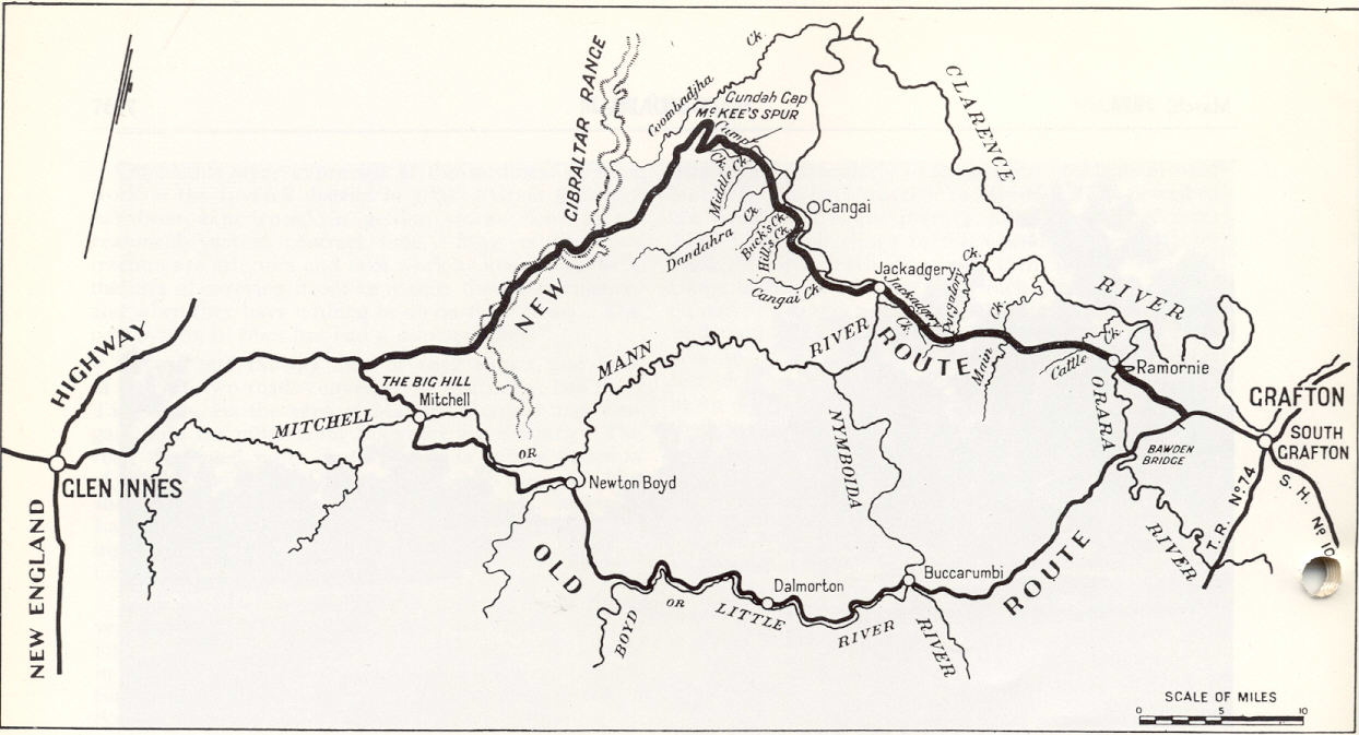
“The main problem was to find a continuous strip of suitable country on the escarpment about 10 miles long to support a descent of about 3,000ft from the tableland. Suitable country was available in the easier slopes near the crests of watersheds, but the lower slopes were generally too steep and broken by deep gullies to support a road. The old Highway route between Glen Innes and Grafton “descends from the tableland to the Mann River Valley and crosses a low saddle in a watershed to reach the Litte River which it follows for 27 miles between steep mountain sides to the Nymboida River . The Nymboida River is then traversed to South Grafton . The descent of about 2,200 feet into the Mann River Valley is spread over a distance of about seven miles and is made in three stages. The alignment on the descent is tortuous, particularly on the steep intermediate stage known as The Big Hill. On The Big Hill, the road falls a little more than 1,000 feet in 2.5 miles and follows a zigzag course with hairpin turns in order to make sufficient distance for the grade. Parts of the road along the Little River are in narrow rock cutting on steep side slopers. In one place, a very steep rock bluff alongside the Little River is negotiated by means of a [66m] tunnel.”6 The new route from Glen Innes to South Grafton follows an existing road over rolling to hilly tableland country to a point 21 miles east of Glen Innes. “The deviation then passes for about 25 miles through eucalyptus forests and undulating tableland country in the vicinity of Gibraltar Range, on an elevation corresponding approximately to that of Glen Innes, about 3,500 feet. The descent of about 3,000 feet from the tableland is then made on a length of about 11 miles on an average grade of about 5.3% with maximum grades of 7%. This descent is mainly through dense rainforest interspersed with hardwood timber on side slopes which, although steep, are considerably easier and less broken than the average slopes of the escarpment… From the foot, the route follows up the Mann River Valley on undulating grades, with occasional heavy cuts, to cross the Mann River at Jackadgery. From Jackadgery to the existing Gwydir Highway near South Grafton , the general route of a local access road is followed through the foothills.”7
Construction of the new route was commenced as unemployment relief work in 1939 but by October 1942 wartime operations had made it necessary to halt work indefinitely. Work was resumed in December 1946 on a normal basis but was halted again a year later when it became necessary to divert men and plant to construct forestry roads in the upper Hastings River area - work which was considered urgent and essential to facilitate timber production for housing purposes. Financial difficulties associated with rising costs and the urgency of works elsewhere meant construction was not resumed again until January 1955. The 73 mile deviation was officially opened to traffic on 9 December 1960 , at which time the Department had provided a bitumen surface on 29 miles between Grafton and South Grafton . Following opening, new concrete bridges were constructed over the Mann River at Jackadgery (October 1961) and the Orara River at Ramornie (May 1966) to replace timber bridges that were unsuitable for carrying highway traffic. New bridges were constructed over the MacIntyre River at Inverell in March 1983 and over the Mehi River west of Moree in December 1995. In December 1993 the Highway was fully sealed to Collarenebri and an extension was proclaimed - from Collarenebri to the Castlereagh Highway near Walgett along an existing sealed road. Today the Gwydir Highway carries the National Route 38 shield for its entire length and is declared State Highway No. 12. The RTA has not released plans for any new construction on the Highway. |
1. Department of Main Roads; Historical Roads of New South Wales : Gwydir Highway : Extracts from March, 1954 and March, 1961 Issues of ‘Main Roads’: Journal of the Department of Main Roads New South Wales ; 1980; p.72-73
2. Department of Main Roads; Historical Roads of New South Wales : Gwydir Highway : Extracts from March, 1954 and March, 1961 Issues of ‘Main Roads’: Journal of the Department of Main Roads New South Wales ; 1980; p.77
3. Department of Main Roads; Historical Roads of New South Wales : Gwydir Highway : Extracts from March, 1954 and March, 1961 Issues of ‘Main Roads’: Journal of the Department of Main Roads New South Wales ; 1980; p.76
4. Department of Main Roads; Historical Roads of New South Wales : Gwydir Highway : Extracts from March, 1954 and March, 1961 Issues of ‘Main Roads’: Journal of the Department of Main Roads New South Wales ; 1980; p.76
5. Department of Main Roads; Historical Roads of New South Wales : Gwydir Highway : Extracts from March, 1954 and March, 1961 Issues of ‘Main Roads’: Journal of the Department of Main Roads New South Wales ; 1980; p.76
6. Department of Main Roads; Historical Roads of New South Wales : Gwydir Highway : Extracts from March, 1954 and March, 1961 Issues of ‘Main Roads’: Journal of the Department of Main Roads New South Wales ; 1980; p.75
7. Department of Main Roads; Historical Roads of New South Wales : Gwydir Highway : Extracts from March, 1954 and March, 1961 Issues of ‘Main Roads’: Journal of the Department of Main Roads New South Wales ; 1980; p.76