Metroad 7 |
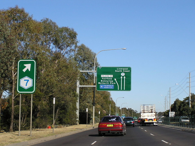
Metroad 7 trailblazer and lane allocation AD sign southbound on the former alignment of Metroad 7, at Polding St, Fairfield West. June 2004.
In 2013, RMS will be implementing a new alpha-numeric route numbering system. For more information, visit the RMS Website. |
|
Forthcoming alpha-numeric route number: |
|
Length: 7km
Northern Terminus: Pacific Hwy & Cumberland Hwy (Pennant Hills Rd), Pearces Corner (Wahroonga)
Southern Terminus: Cumberland Hwy (Pennant Hills Rd) & Hills (M2) Motorway, Beecroft
Route Taken: Cumberland Highway (Pennant Hills Rd)
Focal Points: Hornsby/Newcastle, Parramatta/Canberra
RTA Internal Classification: State Highway No. 13
Metroad 7 was the major route for through traffic bypassing Sydney, particularly between the Pacific and Hume Highways. However, from December 2005 it has become quite a useless route, stretching only from the Pacific Highway at Pearces Corner south to the Hills (M2) Motorway at Beecroft - a mere 7km. The reason for this is quite simple - route marking in New South Wales is in a time of change. The RTA is currently in a very drawn-out process of converting NSW from the existing three-tier shielded route marking system to the alpha-numeric route marking system, consistent with that currently used in Victoria, South Australia and Tasmania.
How does this relate to Metroad 7? Well, as I mentioned earlier, Metroad 7 was the major route for through traffic bypassing Sydney between the Pacific and Hume Highways. However, on 16 December 2005 the Westlink M7 was opened to traffic and assumed that role, ahead of the existing Metroad 7 route. Upon opening, the new motorway received the "M7" route marker, which is the alpha-numeric equivalent of Metroad 7 and Metroad 7 was thus decommissioned between Prestons and Carlingford. Because the signposting of route "M7" was not continued north along Pennant Hills Rd from the M2 Motorway junction at Carlingford, a 7km section of Metroad 7 remains as a de-facto "A7". This remaining section will be converted to "A7" when the entire alpha-numeric system is rolled out (likely around 2009 or 2010) or the RTA may wait until construction of the underground motorway between the M2 and F3 is completed (2017?).
A brief history of Metroad 7
Metroad 7 was introduced in mid-1993 and stretched from the Pacific Highway at Wahroonga to the Princes Highway at Heathcote, via Cumberland Highway, Hume Highway and Heathcote Road, and providing a bypass of eastern Sydney for traffic passing between the Pacific Highway and the Hume and Princes Highways. An RTA promotional brochure described the route of Metroad 7 at the time of its commissioning as follows:
"Heading north, Metroad 7 starts at the junction of Heathcote Rd and the Princes Highway at Heathcote. It proceeds along Heathcote Rd to the South Western Motorway, then along the Motorway to the Hume Highway at Casula, Hume Highway (northwards), Cumberland Highway including Pennant Hills Rd to Wahroonga...where it joins National Highway 1 (Sydney-Newcastle Freeway). Heading south, Metroad 7 follows the same series of roads to Liverpool, where it proceeds from the Hume Highway via Memorial Ave, Scott St and Newbridge Rd to Heathcote Rd."
The link between the Pacific and Princes Highways, forming an alternative route to Metroads 1 & 3, was reinforced by the introduction of the remote focal points of "North Coast" for northbound traffic and "South Coast" for southbound traffic. These focal points were included on all major AD (Advance Directional) signs and many ID (Intersectional Direction) signs, however there were problems with motorists not easily understanding exactly where North Coast and South Coast referred to. As a result, all mentions of "North Coast" were changed to Newcastle (matching the remote focal point on distance signs) and all mentions of "South Coast" were changed to Canberra (north of the M5 Motorway junction). Some "South Coast" signs were retained for Heathcote Road until Metroad 7 was removed along Heathcote Rd in 1999.
The first change to the routing of Metroad 7 came in June 1994 with the opening of the Casula Bypass and an eastbound offramp on the South Western Motorway at the Heathcote Road interchange. Metroad 7 was re-routed at Liverpool, instead using the South Western Motorway (and the new offramp) to get from the Hume Highway to Heathcote Road. As part of the Casula Bypass opening, Metroad 5 was removed from the Hume Highway through Casula and Metroad 7 replaced it. This created a spur for Metroad 7 which allowed Canberra traffic to connect directly to the Hume Highway (National Highway 31) at Glenfield. It was at this time that Metroad 7 began a shift of focus from a Pacific-Princes link to a Pacific-Hume link.
The Pacific to Hume Highway link role of Metroad 7 was further reinforced in 1999, when the last of the Metroads - Metroad 6 - was introduced. As part of Metroad 6's introduction (which extended from Metroad 7 at Carlingford to Metroad 1 at Heathcote), Metroad 7 was removed from Heathcote Road and the South Western Motorway. Metroad 6 replaced Metroad 7 as the more direct link through Sydney between the Pacific and Princes Highways. Thus, the spur of Metroad 7 - Hume Highway from Liverpool to Glenfield - became part of the mainline.
The final change came on 16 December 2005 when the Westlink M7 was opened to traffic, usurping Metroad 7 as the major route through Sydney between the Pacific and Hume Highways. Effective immediately, although taking several months to appear completely on directional signs, Metroad 7 was truncated at the Cumberland Highway/Hills Motorway junction in Beecroft.
For more information/photos of the former alignment of Metroad 7 please see the Former Alignments page.
Explore Metroad 7:
History and Development - of the Cumberland Highway.
Northern Terminus: Pacific Hwy, Pearces Corner
F3 Junction, Wahroonga
Former Alignments: Beecroft-Liverpool, Liverpool and Liverpool-Heathcote
|
Photos of Metroad 7 (current alignment) |
|
 |
Looking south along Pennant Hills Road towards the Normanhurst Rd/Osborn Rd junction at Normanhurst. Dec 2003. |
 |
Now-removed Metroad 7 trailblazer southbound on Pennant Hills Rd approaching Dartford Rd at Normanhurst. All Metroad 7 trailblazers were removed in early 2005 in preparation for Metroad 7's decommissioning south of the M2. Dec 2003. |
 |
Looking south towards Dartford Rd at Normanhurst. Long sections of Pennant Hills Rd have median fences to discourage pedestrians from crossing mid-block. One down side to this treatment is that it heightens the physical barrier that heavily-trafficked roads create between sections of suburbs. Aug 2004. |
 |
Very unusual to see one of these service signs in an urban area given the availability of petrol stations. This one was probably installed as this is the first southbound service station beyond the southern end of the F3. Aug 2004. |
 |
Double chevron ID sign at the intersection of Pennant Hills Rd & Duffy Ave, Thornleigh. The local name of "Pennant Hills Rd' is preferred on directional signs over Cumberland Highway, except on distance signs where both are included. This is probably because Pennant Hills Rd was an established part of the Pacific Hwy/Hume Hwy link well before the naming of Cumberland Hwy. Aug 2004. |
 |
Looking south at The Comenarra Parkway junction, Thornleigh. Dec 2003. |
 |
Following the naming of Cumberland Highway, a programme was launched by the RTA to provide better street name signage along Pennant Hills Road, including plenty of this type of AD sign. This particular one is northbound approaching George St at Pennant Hills. Aug 2004. |
 |
Looking north to the railway underpass and the pedestrian overpass at Pennant Hills Railway Station. Aug 2004. |
 |
AD sign southbound on Pennant Hills Rd approaching Trebor Rd & City View Rd. This sign is typical of a number of diagrammatic AD signs that were installed as part of an improved signage plan along Pennant Hills Rd during the late 1980s and early 1990s. Note the blank coverplates which cover "Trebor Rd" (bottom) Metroad 2 shield (above Beecroft Rd) and State Route 77 shield (Metroad 7 coverplate). Aug 2004. |
 |
Also installed as part of the original street-name signage plan were these name plates with a route marker included. This sign originally showed State Route 77 but was coverplated with Metroad 7 following its introduction. This sign is located in Trebor Rd, eastbound approaching Pennant Hills Rd at Pennant Hills. Dec 2003. |
 |
Oversized and undersized ID signs on Boundary Rd at the junction with Pennant Hills Rd. Epping and Sydney are reached via Beecroft Rd and the Metroad 7 shield (lower sign) is on a coverplate over the Metroad 2 & 7 duplex. March 2006. |
 |
Unusual lane allocation AD sign that refers to the centre lane of Boundary Rd, at its junction with Pennant Hills Rd. Note the blank coverplate just above the Metroad 7 shield which covers a Metroad 2 shield (Beecroft Rd was part of Metroad 2 from 1993 to 1997). March 2006. |
 |
Distance sign southbound on Pennant Hills Rd, between the two junctions with Beecroft Rd. Sep 2004. |
 |
Northbound lane allocation AD sign approaching the northern leg of Beecroft Rd. Dec 2005. |
 |
Unusual lane allocation AD sign, northbound on Beecroft Rd approaching Pennant Hills Rd. It is unusual because the two lanes go right, not straight ahead at the junction with Pennant Hills Rd. Note the Metroad 7 shield on a coverplate over the Metroad 2/7 duplex, which existed between Beecroft and Castle Hill Roads during 1993-1997. Sep 2004. |
 |
Unusual sign southbound on Beecroft Road at the split. Quite why the Beecroft Rd name is paired up with a Metroad 7 shield is beyond me. Dec 2005. |
 |
Typical afternoon traffic on Pennant Hills Rd, looking north from the southern leg of Beecroft Rd. Sep 2004. |
 |
Distance sign heading north from Cardinal Ave, West Pennant Hills. Oct 2005. |
 |
Southbound lane allocation AD sign approaching Castle Hill Rd at Thompsons Corner. March 2006. |
 |
Unusual gantry sign eastbound on Castle Hill Road at Thompsons Corner. I don't know why two mentions of Epping/Parramatta were needed but only one road name patch sufficed. Also note the use of dual road names, something only seen on distance signs elsewhere on Cumberland Hwy. March 2006. |
 |
Distance sign heading south from Thompsons Corner. March 2006. |
 |
Typical advance street-name signage, northbound approaching Copeland Rd. March 2006. |
 |
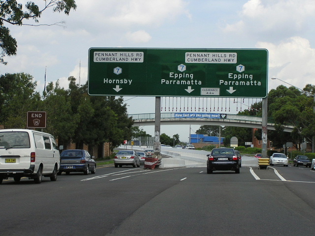
AD sign southbound on Pennant Hills Rd approaching the M2 Hills Motorway at Beecroft. This is now the southern terminus of Metroad 7 and the northern terminus of Metroad 6. March 2006. |
ID signs facing eastbound traffic at the M2 junction, showing Metroad 7 and Metroad 6. March 2006. |
|
 |
AD sign eastbound on the M2 Motorway approaching Pennant Hills Rd, showing Metroads 6 and 7. Jan 2006. |
Last updated 12 December 2012 © Ozroads 2003-2012. |