Metroad 5 |
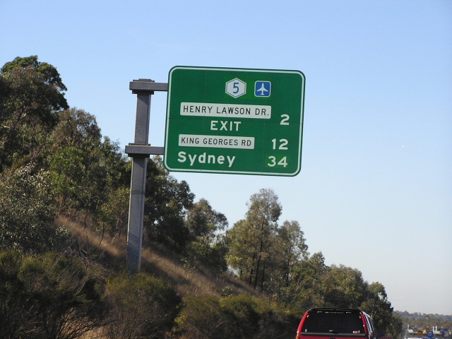
Distance sign on Metroad 5, heading east from Heathcote Rd at Moorebank. April 2004.
In 2013, RMS will be implementing a new alpha-numeric route numbering system. For more information, visit the RMS Website. |
|
Forthcoming alpha-numeric route number: |
|
Length: 47km
Eastern Terminus: General Holmes Dr & South Western Motorway, Kyeemagh
Western Terminus: Hume Hwy & Narellan Rd, Campbelltown
Route taken: South Western Motorway, Hume Highway
Focal Points: Sydney, Liverpool, Campbelltown, Canberra
RTA Internal Classification: Main Road No. 6005 (Motorway), State Highway No. 2 (Hume Hwy)
Metroad 5 is major trunk route from the Airport and CBD to the south-western suburbs, particularly the Liverpool and Campbelltown districts. It is the only Metroad to be fully freeway standard, acheiving this mark in December 2002 when the traffic lights at Moorebank were switched off.
For more information on the history and development of the Hume Highway section of Metroad 5, please see the Hume Highway page. For information on history and development of the South Western Motorway section of Metroad 5 please see the South Western Motorway page.
Metroad 5 was introduced in late 1992 and signing of the route had been completed by February 1993. Being predominately on a new alignment, no one National Route or State Route was decommissioned to make way for Metroad 5, although National Route 31 was truncated and then subsequently downgraded to a state route. The original alignment of Metroad 5 saw it beginning at the Cross Roads intersection at Casula where it met National Highway 31 and State Route 89. Metroad 5 then proceeded north on the Hume Hwy through Casula, thence east along the South Western Motorway, north along King Georges Rd, Wiley Ave and Roberts Rd to the Hume Hwy. From there it followed the Hume and Gt Western Highways before terminating at Harris Street, Ultimo.
The first alignment change came in June 1994 with the opening of the Casula Bypass. Metroad 5 was re-routed from the Hume Hwy onto this new section of motorway, however, it terminated at the Camden Valley Way interchange at Prestons. In 1998 when Metroad 9 was introduced, Metroad 5 was extended south from Prestons along the Hume Highway to Narellan Rd. The final alignment change came in December 2001 with the opening of the M5 East. Metroad 5 was decommissioned from its King Georges Rd/Hume Hwy etc. routeand re-routed onto the newly-opened section of motorway. Metroad 5's eastern terminus thus became the interchange with General Holmes Dr at Kyeemagh.
South Western Motorway
Hume Highway
Metroad 5 - Photos of the Prestons to Campbelltown (Hume Hwy) section |
|
 |
Looking south on the Hume Highway just south of Campbelltown Road overpass at Glenfield. This photo shows widening of the southbound carriageway to four lanes underway. Aug 2005. |
 |
2km AD sign for the Brooks Road interchange. June 2004. |
 |
ID sign pointing traffic from Brooks Road onto the Hume Hwy northbound at Ingleburn. June 2004. |
 |
What was formerly the first RD sign southbound on National Highway 31 is now the last RD sign westbound on Metroad 5 at Ingleburn. May 2005. |
 |
Southbound approaching Campbelltown Road exit at Raby. Aug 2005. |
 |
Southbound 1km from Campbelltown Rd exit at Raby. Aug 2005. |
 |
Signage on Campbelltown Road southbound for the Hume Hwy at Raby. June 2005. |
 |
RD sign heading north from Campbelltown Road. Since there is hardly anything northbound on the Hume between Narellan Rd and The Cross Roads i had to put this less-than-ideal photo up. Better photo coming soon! Oct 2004. |
 |
Metroad 5 trailblazer (that was formerly a NH31 trailblazer) heading south from Campbelltown Rd. Aug 2005. |
 |
Southbound approaching Narellan Road. Note the incorrect Metroad 5 shield straight ahead. Metroad 5 ends at this interchange. July 2004. |
 |
Narellan Rd south-east bound approaching the Hume Hwy at Campbelltown. July 2004. |
 |
More signage showing the change from Metroad 5 to NH31. July 2004. |
 |
Narellan Rd north-westbound at the Hume Hwy interchange. Aug 2004. |
 |
Looking south beneath the Narellan Rd overpass at Campbelltown. This overpass marks the change western terminus of Metroad 5. Aug 2004. |
 |
The sign marking the end of Metroad 5. Note the word "Motorway" - this is incorrect as the motorway ended about 17km earlier at Prestons. Aug 2004. |
|
Former Alignment: Beverly Hills to Ultimo via King Georges Rd/Wiley Ave/Roberts Rd/Hume Hwy/Gt Western Hwy |
|
 |
The South Western Motorway eastbound at its former terminus of King Georges Rd with a sign pointing Metroad 5 traffic north onto Metroad 3. Note the pre-Metroad focal point of 'Strathfield'. Feb 1997. |
 |
Metroad 3 northbound approaching the former Metroad 5 duplex at Beverly Hills. Nov 1998. |
 |
ID sign pointing Metroad 5 traffic onto Metroad 3 northbound at the same intersection. |
 |
Metroads 3 & 5 northbound approaching former State Route 27 at Wiley Park. Nov 1996. |
 |
Punchbowl Rd eastbound approaching Wiley Ave and King Georges Rd at Wiley Park. Nov 1996. |
ID signs at the King Georges Rd/Wiley Ave/Punchbowl Rd intersection. Nov 1996. |
|
ID signs at the same intersection. Note that because of the Olympics the focal point of 'Ryde' has been replaced by 'Homebush Bay' then 'Sydney Olympic Park'. Nov 1996. |
|
 |
Another Metroads 3&5 ID sign at the same intersection. Nov 1996. |
 |
Wiley Ave southbound approaching Punchbowl Rd. 1996. |
 |
Metroad 5 also duplexed with Metroad 4 for several kilometres at its eastern end, replicating the NR31/NR32 duplex that existed for 40 years. This sign is eastbound on Gt Western Hwy approaching Hume Hwy at Summer Hill. 2000. |
 |
Gt Western Hwy eastbound at Tebbutt St, Petersham. 2000. |
 |
ID signs showing Metroad 4 and 5 shields at the overpass of Parramatta Rd at Petersham. 2000. |
 |
Signage on Tebbutt St southbound approaching Parramatta Rd at Petersham. 2000. |
 |
The former first RD sign on Metroad 5, heading west on Gt Western Hwy (Parramatta Rd) alongside Sydney Uni. 2000. |
 |
Gt Western Hwy westbound approaching the beginning of the Princes Hwy at Chippendale. 2000. |
 |
Metroad 5 signage at the Gt Western/Princes Hwy intersection at Chippendale. 2000. |
Signage on Abercrombie St northbound approaching Metroads 4 & 5 at Broadway. 1994. |
|
Signage at the Gt Western Hwy/Abercrombie St/Wattle St intersection. 1994 |
|
 |
Extremely rare 'Start Metroads 4 & 5' sign at the Gt Western Hwy/Harris St intersection. 2000. |
 |
Metroad 5 remnant that still remains today on Harris St southbound approaching the Gt Western Hwy. April 2004. |
 |
Another Metroad 5 remnant, southbound on Harris St approaching Pier St. I find it quite ridiculous that the Metroad 5 shields still remain here despite the removal of SR66 shield from this sign in June 2004. June 2005. |
 |
Another Metroad 5 remnant on Harris St, this time at Quarry St. April 2004. |
Last updated 12 December 2012 © Ozroads 2003-2012. |