NSW METROAD 2
Former Alignment: Sydney CBD to Lane Cove
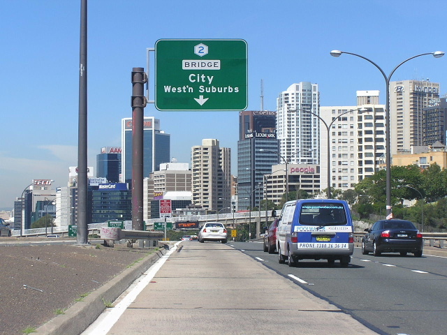
Overhead sign southbound on Warringah Freeway, south of Falcon Street, showing Metroad 2 across the Sydney Harbour Bridge. Feb 2005.
Lifespan: 1993-2006 (13 years)
Length: 9km
Northern Terminus: Pacific Hwy & Gore Hill Fwy & Longueville Rd, Lane Cove
Southern Terminus: Bradfield Hwy & Cahill Expressway & Western Distibutor & Grosvenor St & York St & Clarence St & Kent St, Millers Point
Route taken: Bradfield Highway, Warringah Freeway, Gore Hill Freeway
When Metroad 2 was first introduced, its south-eastern-most section directly followed the alignment of State Route 28 which had been recently extended from Lane Cove to the Sydney CBD via the Gore Hill Freeway, Warringah Freeway and Bradfield Highway. According to the RTA, Metroad 2 actually extended further south - following Western Distributor, Harris St and Regent St to terminate at Cleveland St (former Metroad 4) in Chippendale (northbound traffic used Abercrombie, Wattle & Fig Streets rather than Harris & Regent Streets due to a one-way system in operation through Ultimo/Chippendale). However, no Metroad 2 shields were ever erected south of the southern Harbour Bridge toll plaza and northbound signs for a long time showed "To Metroad 1" or just referred to the Harbour Bridge itself. More recently, "To Metroad 2" signs appeared along Abercrombie, Wattle and Fig Streets, however they have since been removed.
Metroad 2 was truncated at Lane Cove in July 2006, as part of an ongoing reorganisation of route marking in Sydney, associated with the eventual introduction of an alpha-numeric route marking system. Photos in this section will show those "To Metroad 2" signs from the Chippendale/Ultimo area as well as photos of Metroad 2 shields along the Gore Hill & Warringah Freeways, and the Bradfield Highway.
Photos of Metroad 2 former alignment: Lane Cove to Sydney CBD
|
|
 |
ID sign at the intersection of Kent St and the on-ramp to Bradfield Hwy at Millers Point, showing Metroad 2 as well as Metroad 1. Nov 2006. |
 |
AD sign underneath the Western Distributor viaduct at Millers Point, facing Clarence Street traffic. Nov 2006. |
 |
AD sign northbound on Bradfield Hwy adjacent to Milsons Point railway station, showing Metroad 2. Nov 2005. |
 |
Northbound gantry signs on Bradfield Hwy adjacent to the Lavender Street ramps. April 2004. |
 |
Northbound gantry signs mounted on the High Street overpass - this is now the Warringah Freeway. Nov 2005. |
 |
Metroad 2 shield on an ID sign, southbound on Warringah Freeway just south of Ridge Street. Feb 2005. |
 |
Overhead signs mounted to the Ridge Street footbridge, showing Metroad 1/2 duplex. March 2006. |
 |
Metroad 2 sign on the southbound on-ramp from Falcon Street to the Warringah Freeway. This sign now has "To Metroad 4" as do most of the other southbound Metroad 2 signs. April 2004. |
 |
Northbound overhead signs on the Falcon St overpass showing the former SR26 as well as the former Metroad 1/2 duplex. March 2004. |
 |
Northbound "butterfly" sign assembly at the Ernest Street off-ramp. March 2004. |
 |
AD sign westbound on Ernest Street showing former Metroad 1/2 duplex. April 2004. |
 |
Overhead signs mounted on the Ernest Street overpass for southbound traffic, showing Metroad 2 shield. These signs are shown in their AM Peak configuration - at other times the information is combined on one sign as the right-hand carriageway is not used for southbound traffic. April 2004. |
 |
Overhead signs for southbound traffic between Ernest and Miller Streets, shown in their AM Peak configuration. March 2006. |
 |
Large AD sign southbound Miller Street at the Warringah Freeway, showing Metroad 2 as the route across the Harbour Bridge. March 2006. |
 |
Overhead signs for northbound traffic mounted on the Miller Street overpass, showing the former Metroad 1/2 duplex. Aug 2006. |
 |
Overhead signs for southbound traffic mounted on the Miller Street overpass, shown in their AM Peak configuration. March 2006. |
 |
Overhead sign mounted on the Warringah Freeway overpass at Brook Street, facing northbound traffic. Note, apart from the Metroad 2 shield, that the "Warringah Freeway" name is used rather than just "Freeway" as is the norm in NSW. April 2004. |
 |
Cantilevered sign on the eastbound on-ramp from Brook Street to the Warringah Freeway at Cammeray. April 2004. |
 |
AD sign on Brook Street southbound approaching the Warringah Freeway at Cammeray. April 2004. |
 |
Cantilevered AD sign southbound on Willoughby Road approaching the Warringah Freeway at Naremburn. March 2006. |
 |
AD sign westbound on Gore Hill Freeway between Willoughby Road and the North Shore railway line, showing exit arrangments for Reserve Rd & Pacific Hwy. This sign was removed prior to the decommissioning of this section of Metroad 2 due to construction works. Feb 2005. |
 |
Overhead signs for westbound traffic mounted on the Hampden Rd/Herbert St overpass at Artarmon. This sign was removed prior to the decommissioning of this section of Metroad 2 due to construction works. June 2005. |
 |
Cantilevered AD sign northbound on Reserve Road approaching the Gore Hill Freeway, showing the former Metroad 1/2 duplex. Aug 2006. |
 |
Cantilevered AD sign southbound on Pacific Highway approaching the Gore Hill Freeway at Artarmon. Feb 2005. |
 |
Overhead signs mounted on the Pacific Highway overpass, eastbound on Longueville Rd as it turns into the Gore Hill Freeway. March 2006. |
 |
AD sign eastbound on Epping Road approaching Longueville Road at Lane Cove, showing Metroad 2 continuing along the Gore Hill Freeway. March 2006. |
|
"To Metroad 2" signage located in the Chippendale/Ultimo area |
|
 |
AD sign westbound on Cleveland St approaching Abercrombie St, Chippendale, showing "To Metroad 2". This sign was installed in about 2001, following the completion of the City West Link to Dobroyd Pde, and was replaced with a new sign in about mid-2005 to coincide with the opening of the Cross City Tunnel. April 2004. |
 |
ID sign facing eastbound traffic at the intersection of Cleveland & Abercrombie Streets, Chippendale. This sign was installed in about 2001, following the completion of the City West Link to Dobroyd Pde, and was replaced with a new sign in about mid-2005 to coincide with the opening of the Cross City Tunnel. April 2004. |
 |
Northbound AD sign on Abercrombie Street approaching Broadway. April 2004. |
 |
Eastbound AD sign on Broadway approaching Wattle and Abercrombie Streets. Feb 2005. |
 |
Northbound AD sign on Wattle St approaching William Bailey St, Ultimo. April 2004. |
 |
Northbound AD sign on Wattle St approaching Fig Street. April 2004. |
 |
Southbound ID sign at the Wattle St & Fig St intersection. April 2004. |