METROAD 2 & STATE ROUTE 40 DUPLEX
Windsor Road

Trailblazer on a remaining two-lane section of Windsor Rd at Rouse Hill. April 2005.
Length: 15km
Eatern Terminus: Windsor Rd & Old Windsor Rd, Kellyville
Western Terminus: Bridge St & Macquarie St, Windsor
Year Introduced: Nov 1993
Overview:
Metroad 2 and State Route 40 duplex for 15km along Windsor Rd from Kellyville to Windsor. The duplex was introduced in Nov 1993 - when Metroad 2 was signed. However, initially Metroad 2 used Showground Rd to connect to Windsor Rd so the duplex extended 5km further east than it currently does. Metroad 2 was shifted onto Old Windsor Rd in May 1997, creating the current duplex situation.
Windsor Road Upgrade:
Windsor Rd (between Parramatta and Kellyville) was constructed as the new route to Windsor - completed in November 1812. The section from Kellyville to Windsor had been in use (along with Old Windsor Rd) since 1794. The upgrading of the road to modern standards began in the 1970s, widened to four lanes from Parramatta to Baulkham Hills to serve the Castle Hill urban release area and a new flood-free bridge constructed across South Creek at Windsor (opened December 1974). The major expansion of the road didnt come until 2001 when the State Government launched its "All the way to Windsor" program to upgrade Windsor and Old Windsor Roads to four lanes all the way to Windsor by 2006. Prior to commencement of the program, Windsor Rd was two lanes for its entire length, except for between Barney St, North Parramatta and Roxborough Park Rd, Baulkham Hills as well as a short four lane section between Showground Rd and Memorial Ave, Kellyville. The widening program was split into several sections, construction priority allocated according to the extent of congestion on each section. The first stage of the upgrade, 6-lane divided road from Old Windsor Rd to Merrivale Rd was opened to traffic in October 2002 as part of the Old Windsor Rd upgrade project. The second stage continued north-west from Merrivale Rd to Schofields Rd, with only 4 lanes this time, and was opened to traffic in September 2003. Meanwhile, widening work was in progress between Level Crossing Rd, Vineyard, and Pitt Town Rd, McGraths Hill - this work opening to traffic in April 2004. Also opened in April 2004 was the section from Schofields Rd to Mile End Rd at Rouse Hill. The latest work to be completed is the Norwest Boulevard to Showground Rd section at Castle Hill - opened to traffic in December 2004. This leaves four uncompleted projects:
- Roxborough Park Dr, Baulkham Hills to Norwest Bvd, Castle Hill (construction expected to start mid-2005)
- Acres Rd to Old Windosr Rd, Kellyville (packaged with above project)
- Mile End Rd, Rouse Hill to Boundary Rd, Box Hill (construction expected to start mid-2005)
- Boundary Rd, Box Hill to Level Crossing Rd, Vineyard (construction underway: expected completion 2006)
Also included as part of the 'All the way to Windsor' project is a new flood-free route across South Creek between Railway Rd at Mulgrave and Richmond Rd, Windor. Construction is expect to commence mid-2005 and be completed late 2006.
Photos of the Metroad 2 & State Route 40 duplex |
|
 |
Approaching the start of the duplex from Old Windsor Rd. April 2005. |
 |
Heading north on Windsor Rd from Old Windsor Rd. Apr 2005. |
 |
Looking north-west at Merrivale Rd. April 2005. |
 |
The temporary end of upgraded road at Schofields Rd. Jan 2004. |
 |
End of the upgraded road at Rouse Hill. April 2005. |
 |
Looking west from Mile End Rd and Rouse Rd, showing construction of the deviation around the old Rouse Hill Primary School. Oct 2005. |
 |
Construction underway on the Mile End Rd to Schofields Rd section in January 2004. |
 |
Heading south-east from Garfield Rd East at Box Hill. Mar 2005. |
 |
North-west bound approaching Garfield Rd East at Box Hill. April 2005. |
 |
North-west bound leaving Garfield Rd East through a particularly rural-looking section of Windsor Rd. April 2005. |
 |
Looking west from Garfield Rd East showing duplication underway. Oct 2005. |
 |
1974 relic fingerboards at Junction St, Vineyard. April 2004. |
 |
Very old Parramatta kilometre plate near Boundary Rd. April 2004. |
 |
Constructrion adjacent to the road near Boundary Rd, Vineyard. April 2005. |
 |
Looking west through Vineyard showing 2-way traffic operating on the new westbound carriageway. Oct 2005. |
 |
The return to upgraded road at Henry Rd, Vineyard. April 2005. |
 |
Unusual flood evacuation route sign on Windsor Rd near Groves Ave, McGraths Hill. Mar 2005. |
 |
Upgrading underway near Groves Ave, McGraths Hill. Jan 2004. |
 |
Heading south-east from Mulgrave Rd at McGraths Hill. Mar 2005. |
 |
Four lane road through McGraths Hill. April 2005. |
 |
1940 photo showing very old style directional signage at McGraths Hill. |
 |
The equivalent sign 54 years later. Aug 2004. |
 |
Looking north-west across the South Creek floodplain. April 2005. |
 |
'All the way to Windsor' program sign on the South Creek floodplain. Mar 2005. |
 |
The first RD sign heading south-east from Windsor. Mar 2005. |
 |
"Start Metroad 2" sign at the South Creek bridge. Mar 2005. |
 |
The end of Metroad 2 at Windsor. SR40 continues west through Richmond to Lithgow. April 2004. |
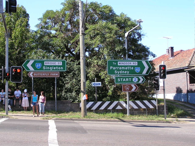 |
ID signs pointing out the start of Metroad 2 at Windsor. April 2005. |
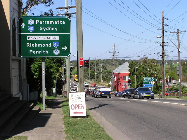 |
Bridge St south-east bound approaching the start of Metroad 2 at Windsor. April 2005. |
Back to Metroad 2
Back to State Route 40