NSW METROAD 10 Northern Beaches |
Former Alignment: Neutral Bay to Lane Cove
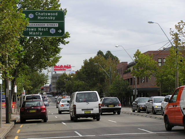
AD sign northbound on Pacific Highway, approaching Alexander St (which leads to Falcon St) at Crows Nest. March 2006.
Lifespan: 1998-2007 (9 years)
Length: 5km
Eastern Terminus: Warringah Freeway & Falcon St, Neutral Bay
Western Terminus: Pacific Hwy & Gore Hill Fwy & Longueville Rd, Lane Cove
Route taken: Falcon St, Pacific Hwy
When Metroad 10 was first introudced, in 1998, it followed directly the route of the former State Route 14, via Falcon Street and Pacific Highway. This was done because, until the opening of the Lane Cove Tunnel in December 2006, there was no connection from Falcon Street to the Warringah Freeway northbound and thus traffic proceeding along Metroad 10 towards Lane Cove, Chatswood and Epping had to go via Crows Nest. There was also no southbound off-ramp from Warringah Freeway to Falcon Street so traffic from the Lane Cove, Chatswood and Epping areas also had to pass through Crows Nest.
With the opening of the Lane Cove Tunnel in March 2007, north-facing ramps at the Warringah Freeway/Falcon Street interchange were opened to traffic. This meant there was now a direct connection between Military Road and Lane Cove, removing the need for through traffic to pass through Crows Nest. Thus, Metroad 10 was duly truncated at the Warringah Freeway.
Photos of Metroad 10 former alignment: Neutral Bay to Lane Cove
|
|
 |
AD sign westbound on Falcon St approaching Warringah Freeway at Neutral Bay. This is now the southern terminus of Metroad 10. March 2006. |
 |
ID sign at the Falcon St & Warringah Freeway interchange, showing Metroad 10 along Falcon St. April 2004. |
 |
AD sign westbound on Falcon St approaching Miller St, North Sydney. Nov 2006. |
 |
ID sign assembly northboound on Miller St at Falcon St, showing Metroad 10 on Falcon St. April 2004. |
 |
AD sign westbound on Falcon St approaching Pacific Highway at Crows Nest, showing Metroad 10 turns north onto Pacific Hwy. Aug 2005. |
 |
ID sign at the intersection of Pacific Hwy & Alexander St, Crows Nest. For northbound traffic, Alexander St provides a connection to Falcon St because of the right-turn ban at Crows Nest Junction. March 2006. |
 |
ID signs at the junction of Pacific Hwy, Falcon St, Shirley Rd and Willoughby Rd (Crows Nest Junction). These signs date from the very early 1990s. April 2004. |
 |
AD sign southbound on Pacific Highway approaching Crows Nest Junction. Note how Citybound traffic is directed to the Warringah Freeway via Falcon St. March 2006. |
 |
Dual ID signs at the junction of Pacific Hwy & Albany St, Crows Nest. Have you noticed that most of the Metroad 10 shields are on coverplates over State Route 14? April 2004. |
 |
ID sign at the junction of Pacific Hwy & Christie St, St Leonards. April 2004. |
 |
Double-chevron ID sign at the intersection of Pacific Hwy & Greenwich Rd, St Leonards. June 2006. |
 |
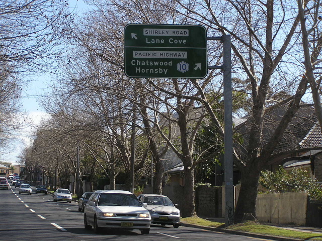
Overhead signs on Longueville Rd where it becomes the Gore Hill Freeway, showing Metroad 10 via the loop ramp. March 2006. |
 |
AD sign eastbound on Epping Road, showing Metroad 10 via the Pacific Highway loop ramp. March 2006. |
 |
ID sign at the intersection of Pacific Hwy & the Gore Hill Freeway ramps, Lane Cove, showing Metroad 10 via Pacific Hwy. Nov 2006. |
 |
AD sign on the Gore Hill Freeway offramp, showing Metroad 10 via Pacific Highway. Nov 2006. |
 |
AD sign on Pacific Hwy southbound approaching the Gore Hill Freeway, showing Metroad 10 straight. Feb 2005. |
Last updated 25 March 2007 © Ozroads 2004-2007. |