Former State Route 42 Prospect - Blacktown - Oakhurst (?) |
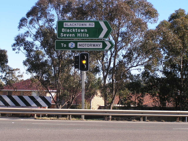
ID sign assembly at the intersection of Blacktown Rd & Prospect Hwy - the blank coverplate covers SR63 which replaced SR42 in 1992. July 2006.
Lifespan: circa. 1985-1992 (7 years)
Length: 11km
Western Terminus: Richmond Rd & Rooty Hill Rd North, Oakhurst
Eastern Terminus: Great Western Hwy & Prospect Hwy, Prospect
Route taken: Prospect Hwy, Blacktown Rd, Main St, Richmond Rd
Focal points: unknown, except for Blacktown
RTA Internal Classification: Main Road No. 641 (Prosect Hwy/Blacktown Rd) unclassified roads (Main Street/Richmond Rd east of Lancaster St), Main Road No. 643 (Richmond Rd west of Lancaster St)
Route Overview:
‘State Route 42…WHAT?!?!’ probably sums up what you are thinking right now – its certainly what went through my head when I first heard about this state route in January 2007.
Apparently a State Route 42 existed for some time during the late 1980s in Sydney’s western suburbs – the Prospect/Blacktown area to be precise. Very little is known about this state route – I have never seen it on any Department of Main Roads map (whether it be an old focal point map, a route marking map, or a road classification map) or street directory and I am also yet to see a photograph of any signs showing the route. However, what we do have is some recollections of the former route to help piece together its story…
Charlie Magnus alerted me to its existence and provided the following recollections:
“ In 1983 my mother was working as a nurse at Blacktown Hospital. My dad and I always took her to work. We took the Ponds Road/Prospect Highway ramp (the cemetery side) and back then I could recall a sign which had Blacktown (and another suburb/city below it), and interestingly enough it also had a State Route [shield] that was covered over.
Towards the end of the 1980s the signs were re-done depicting SR42, then it became SR63.
Along all the roads (Ponds Rd/Prospect Hwy/Blacktown Rd) were the blacked out SR which progressed to SR42 Then SR63. As far as I could observe the SR's headed into Blacktown or at least the intersection of Blacktown Rd/Main St and Sunnyholt Rd/Newton Rd.“
Josh Hoogenboom remembers seeing State Route 42:
“I do remember seeing a SR42 shield as well. As I remember, it was on a very dark green / Black ID sign approching the Prospect Hwy/Blacktown Road intersection northbound. It was showing SR42 and Blacktown going straight. And I remember as well having another location on it, but don't know what it was.”
Craig Crompton remembers seeing the route:
"as a youngster circa late 80s I do recall a SR42 sign on Ponds Road (off Great Western Hwy). Don't recall seeing any SR42 signage beyond that point."
Paul Rands also remembers seeing the signage with blank coverplates on it around the same time.
Based on these recollections and knowledge of typical DMR signage practices, I believe this is the likely chain of events:
- New signage installed along Blacktown Road and Prospect Highway during the early-to-mid 1980s would have made provision for State Route 42 but have had the shields coverplated until the route was unveiled
- Construction of Prospect Highway between Blacktown Road and the Great Western Highway, to replace Church Lane, was undertaken during the mid 1980s, in conjunction with the construction of ramps to/from Great Western Highway. Upon opening of these works, it is likely that State Route 42 signage was introduced.
- Around this time, the Bungarribee Road/Lancaster Street route was developed as a bypass of Blacktown CBD , rendering the Main Street alignment of State Route 42 rather redundant
- Following the construction of the M4 Motorway between Mays Hill and Eastern Creek in 1992, State Route 42 was replaced by State Route 63.
To fit in with the pattern of State Route numbering in Sydney, State Route 42 would have had to be a radial route located between route 40 (Victoria Rd/Windsor Rd) and route 44 (Great Western Highway). This indicates it probably began at Prospect and followed Blacktown Road and thence Richmond Road to Oakhurst, where it probably terminated at State Route 61 (Rooty Hill Road North). It is unlikely the route went either via Sunnyholt Road to Kellyville or via Wall Park Ave & Prospect Hwy towards Old Windsor Rd, as it would then become a circumferential route thus incompatible with the pattern of route numbering in Sydney.
However, this probable route is yet to be confirmed.
State Route 63 was introduced in 1992, directly replacing the former State Route 42. However, it is possible that State Route 42 signage was neglected for several years prior to its demise. Both recollections of this route indicate it was never particularly well-signed, probably explaining why it never appeared on commercial maps.
Last updated 26 January 2011
© Ozroads 2004-2007.