NSW STATE ROUTE 33
Decomissioned
Lifespan: 1974-1993 (19 years)
Length: 53km
Northern Terminus: Pittwater Rd & Mona Vale Rd, Mona Vale
Southern Terminus: Princes Hwy & King Georges Rd, Blakehurst
Route taken: Mona Vale Rde, Ryde Rd, Lane Cove Rd, Devlin St, Church St, Concord Rd, Homebush Bay Dr, Centenary Dr, Roberts Rd, Wiley Ave, King Georges Rd
Focal Points: Mona Vale, Pymble, Ryde, Homebush Bay (formerly Strathfield), Hurstville, Wollongong
RTA Internal Classification: Main Road 162 (Mona Vale to Ryde), Main Road 139 (Devlin St, Ryde), Main Road 200 (Ryde to Blakehurst)
Replaced by: Metroad 3
Route Overview:
State Route 33 was an extremely historic route, replacing the important Ring Road 3 route in 1974. It was the most important non-radial route of its era, passing through the major centres of Ryde, Strathfield and Hurstville, connecting with the Princes, Hume, Gt Western and Pacific Highways. Prior to December 1992, SR33 passed through the middle of Strathfield, along Concord Rd, Leicester Ave, Raw Square, Redmyre Rd, The Boulevard, Coronation Pde and Punchbowl Rd. This section was bypassed by the Homebush Bay Dr/Centenary Dr/Roberts Rd which became SR33 for only a matter of months, Metroad 3 replacing the route during April 1993.
Today, not a single SR33 remains, however there is the odd Metroad 3 shield on a coverplate over a SR33 shield on some sections of road that were constructed in the few years prior to Metroad 3's comissioning. A detailed article on the development of this route is available on the Metroad 3 page.
Notable events in the history of SR33:
February 1901 - Original De Burghs Bridge over Lane Cove River
December 1935 - Ryde Bridge opened to traffic
1964 - Ring Road 1 proclaimed from Mona Vale to Blakehurst
December 1967 - Current De Burghs Bridge opened
1967 - Lane Cove Rd 6-laned between Blaxland Rd & Quarry Rd, Ryde
1968 - Lane Cove & Ryde Roads widened to 6 lanes between Fontenoy Rd, North Ryde and Andrew Ave, West Pymble
1969 - Mona Vale Rd widened to 6 lanes between Cowan Rd & Killeaton St, St Ives
1972 - Wiley Ave constructed
March 1972 - Raw Square extension, Strathfield
February 1974 - Lane Cove Rd opened to traffic between Quarry Rd and Epping Rd, North Ryde
1974 - Ryde Rd 6-laning completed
1974 - SR33 proclaimed
via Strathfield
1975 - Forest Way intersection reconstructed, Terrey Hills
1976 - Pittwater Rd intersection reconstructed, Mona Vale
1977 - Mona Vale Rd 6-laned between Highlands Ave, Pymble and Cowan Rd, St Ives
October 1977 - Deviation east of Terrey Hills cancelled in favour of existing route
July 1978 - Epping Rd interchange, North Ryde opened to traffic
1979 - Mona Vale Rd widened to 6-lanes between Killeaton St & Richmond Ave, St Ives
August 1980 - Mona Vale Rd dual carriageway between Richmond Ave & Forest Way (90km/h section)
1982 - Centenary Dr constructed (Hume Hwy to Arthur St)
November 1988 - Ryde Bridge duplication opened to traffic
December 1988 - Pymble interchange opened to traffic
February 1991 - Homebush Bay Drive (one carriageway) opened to traffic
December 1992 - Terreys Hill dual carriageway (Forest Way to McCarrs Ck Rd)
December 1992 - Centenary Dr extension opened to traffic, SR33 re-routed, old route proclaimed SR27
April 1993 - SR33 replaced by Metroad 3
January 1995 - Homebush Bay Drive duplication
June 1996 - Centenary Drive widened to 6-lanes (Arthur St-Pemberton St)
May 1997 - Cooks River Bridge widened to 6 lanes
February 1998 - Australia Ave interchange
August 1998 - Hume Highway interchange
December 1998 - Victoria Rd interchange
2004 - Duplication at Ingleside around Powder Works Rd
Photos of State Route33 |
|
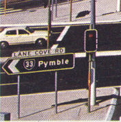 |
1978 photo of SR33 ID sign at the interchange of Lane Cove & Epping Roads, North Ryde. Scanned from Main Roads Journal. |
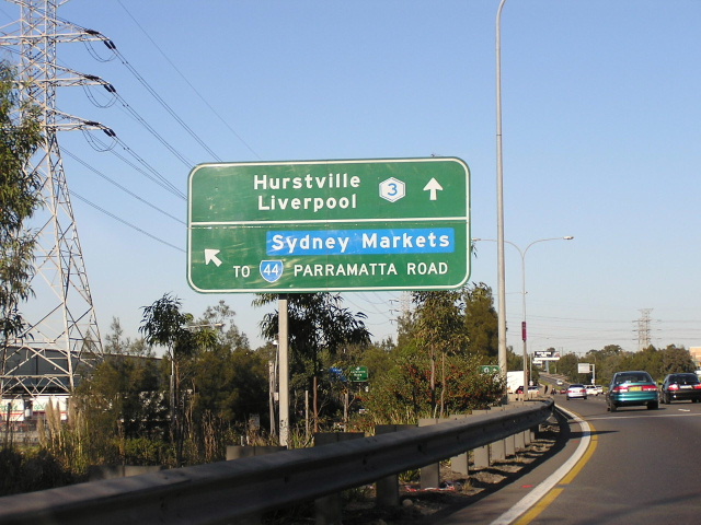 |
Centenary Drive AD sign southbound over Parramatta Rd. This sign has Metroad 3 on a coverplate over SR33. Photo taken October 2004. |
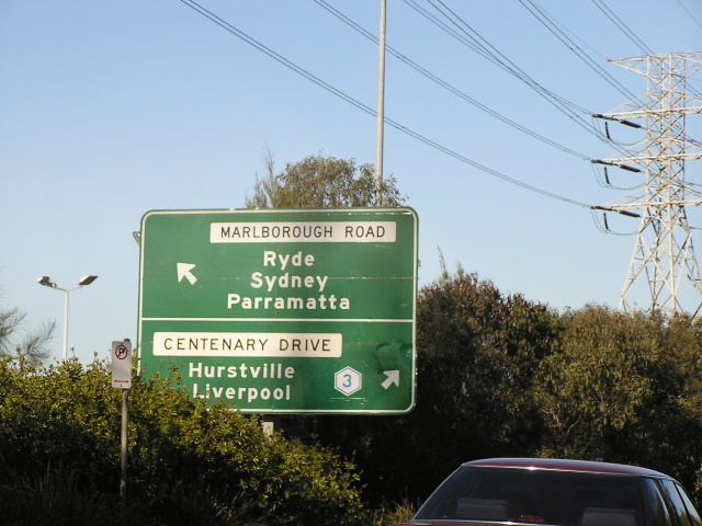 |
Marlborough Rd southbound showing an AD sign for Centenary Dr. Again, the Metroad 3 shield is on a coverplate over a SR33 shield. Photo taken October 2004. |
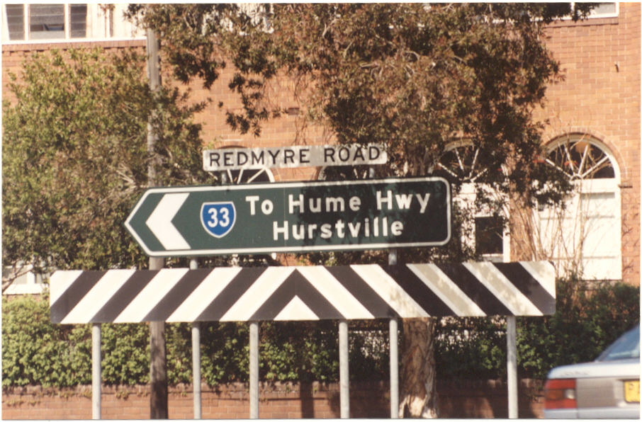
Raw Square southboudn approaching Redmyre Rd, Strathfield on SR33's original alignment. This sign lasted well into the 1990's before being replaced. Photo taken 1994. |
|
 |
Intersection of Redmyre Rd & Raw Square, Strathfield on SR33's original alignment. Photo taken 1994. |
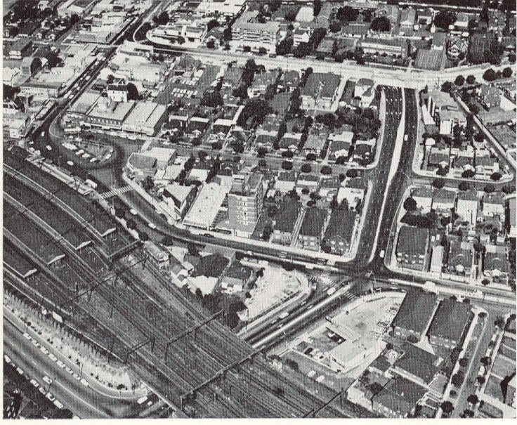 |
Aerial photograph from 1972, showing the Raw Square extension that bypassed Strathfield Square on SR33. |
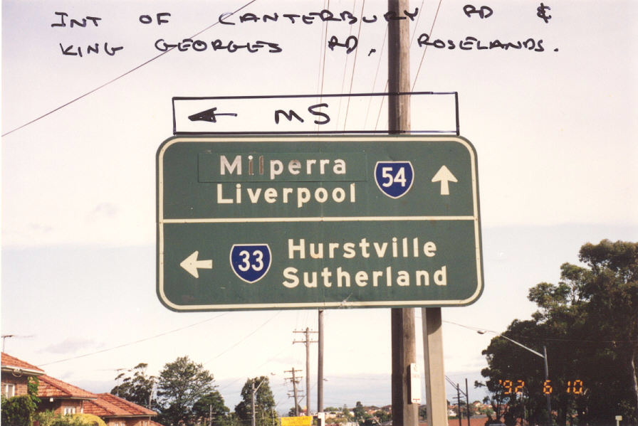 |
Canterbury Rd approaching King Georges Rd at Roselands. Photo taken 1992. |
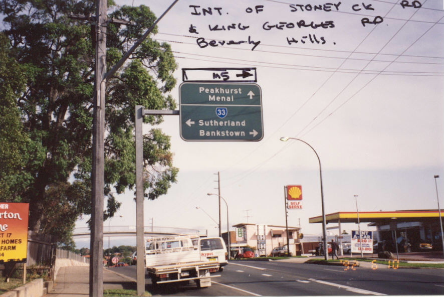 |
Stoney Creek Rd approaching King Georges Rd, Beverley Hills. Photo taken 1992. |