MOUNT LINDESAY HIGHWAY (NSW)
State Highway No. 24 (Decommissioned)
Extremely old and derelict double-chevron ID sign on the old Mt Lindesay Hwy in Woodenbong. Jan 2005.
Lifespan: 1950-1982 (32 years)
Length: 146km (at time of decommissioning)
Northern Terminus: NSW/QLD Border at Mt Lindesay
Southern Terminus: New England Hwy & Naas St, Tenterfield
Route taken: From the New England Hwy via Naas St, Logan St, Old Warwick Rd, Liston, Amosfield, Legume, Woodenbong and Summerland Way to the NSW/QLD border at Mt Lindesay. Former highway is now known as Mt Lindesay Rd and part of Summerland Way.
Main Roads Act 1924 classification: State Highway No. 24
Declared a State Highway: 27 January 1950
Named: 3 September 1954
Decommissioned: 12 February 1982 (reproclaimed as Main Road No. 622 and part of Trunk Road No. 83)
Mount Lindesay Highway, State Highway No. 24, was, at the time of its decommissioning, a 146km long north-south highway in northern New South Wales, stretching from Tenterfield via Woodenbong to the Queensland Border at Mount Lindesay. To this day its former route between Tenterfield remains partly unsealed, winding and steep, which gives some insight into why it was decommissioned.
History:
State Highway No. 24 has had an interesting history. In August 1928, when the Main Roads Board declared the first thirteen State Highways, the route of what would later become Mt Lindesay Hwy was declared as part of State Highway No. 9 – Great Northern Highway (now New England Highway). Further to its role as a State Highway, it was also part of the main Sydney-Brisbane connection. This came about from a push by the NSW and QLD Governments in 1924 to provide a more direct route between Tenterfield and Brisbane, as the existing route via Amosfield, Stanthorpe, Warwick and Toowoomba was indirect and difficult to travel during wet weather. Provision of the new route along the line of Mt Lindesay Hwy (i.e. via Amosfield, Legume and Woodenbong to Mt Lindesay) involved the construction of the missing link between Woodenbong and Mt Lindesay, which was carried out by the Department of Public Works and completed in 1929, and the reconstruction of the existing road between Oakey Creek and Woodenbong – which was completed by the Department of Main Roads in 1934. The existing concrete arch bridge over Kooreelah Creek and the steel girder and concrete structure over the Maryland River were both constructed as part of the latter stage and completed in 1930.
During the immediate post-war years, the Queensland Main Roads Department completed construction of a new high-standard route from Brisbane, via Cunningham’s Gap and Warwick, to Wallangarra. This new route saw increasing traffic volumes as interstate travellers avoided the more difficult Mt Lindesay Highway and a need became apparent for a high-standard road within New South Wales that would link Wallangarra with Tenterfield. An existing road, Main Road No. 374, already linked Tenterfield and Wallangarra but had the disadvantage of crossing the railway line five times in its 14km length, four of which were level crossings and the other a narrow overbridge with right-angle approaches. Thus, the Department of Main Roads resolved the reconstruct the road throughout its length and the work was undertaken by Tenterfield Shire Council. “Between 4.5 miles (7.2km) and 6.5 (10.4km) miles north of Tenterfield the Shire Council completed by contract in 1946, a deviation eliminating two of the level crossings. This deviation involved the construction of a timber beam bridge 65 feet long across Tenterfield Creek.”1 Construction of another deviation, between 17.2 and 19.6km north of Tenterfield, was undertaken immediately afterwards and completed in 1950, eliminating the two remaining level crossings.
On 27 January 1950, Main Road No. 374 was reproclaimed by the Department of Main Roads as State Highway No. 24 but not given a name. Its elevation to State Highway status ensured that future construction would be fully funded by the State on this important connection between New South Wales and Queensland.
However, State Highway No. 24 would soon have a change of fortunes. In 1954 the decision was made by the New South Wales and Queensland Main Roads departments to re-route the New England Highway from Tenterfield to Brisbane via Wallangarra, Stanthorpe, Warwick and Cunningham’s Gap. It was then decided that the former route of the New England Highway, via Woodenbong, Mt Lindesay and Beaudesert would be re-named Mount Lindesay Highway, after the mountain which is passes at the NSW/QLD border. Thus, the gazetted change in New South Wales came on 3 September 1954, revoking the declarations of State Highways No. 9 and No. 24 north of Tenterfield, and thence declaring the Tenterfield-Wallangarra road State Highway No. 9 (New England Hwy) and the Tenterfield-Mt Lindesay road State Highway No. 24 (Mount Lindesay Hwy). Thus, the route of Mount Lindesay Highway (State Highway No. 24) was locked into its ultimate location, and the location we all know it by.
However, its deproclamation as part of the New England Highway was probably just a forerunner to its eventual decommissioning. Whether the Department of Main Roads retained the route as a State Highway still expecting decent traffic flows or whether they were intending to eventually reconstruct and seal is not known. However, prior to 1954 the rugged terrain and isolation of the route meant that the highway gradually fell into disuse as through traffic favoured other, less tortuous routes. This trend continued, following its declaration as the Mount Lindesay Highway, and very little was done to improve the route – with the section from Tenterfield to Legume still mostly unsealed, winding and steep. Continuing problems with land slides and formation instability on the northern side of the border throughout the late 1950s and early 1960s meant that through traffic volumes fell to almost nothing. Ultimately, in 1982, the Mount Lindesay Highway was decommissioned and redeclared mostly as Main Road No. 622 The section from the Queensland Border south to the junction with Summerland Way (Main Road No. 83/State Route 91) was redeclared as part of Summerland Way.
These days, whilst the former route of Mount Lindesay Highway is still a classified Main Road, however it is under the control of Tenterfield and Kyogle Shires. The section south of Legume has traffic volumes of less than 100 vehicles per day in many places, whilst east of Legume the former highway forms part of an important regional cross-border link between the Darling Downs and the NSW northern rivers district.
Under NAASRA’s 1950s plan for the National Route marking system, the Mount Lindesay Highway was earmarked to receive the National Route 13 shield once it had been upgraded to have a dust-free surface along its length. However, this never happened and thus National Route 13 was never signed in New South Wales – the southern extremity of NR13 signage was the Queensland/New South Wales border at Mount Lindesay. Since the highway’s decommissioning in 1981, State Route 91 has been extended north from the junction of Main Road No. 622 (old Mt Lindesay Hwy) and Main Road No. 83 (Summerland Way) to meet Queensland’s State Route 91 at the NSW/QLD Border. This occurred sometime during the mid 1980s, possibly around 1986. The remainder of the old Mount Lindesay Highway does not have a route marker.
|
Photos of the former route of Mount Lindesay Highway |
|
 |
Northbound AD sign on New England Highway approaching the junction with Naas St (old Mt Lindesay Hwy ) in Tenterfield. Jan 2005. |
 |
Looking east along Naas St in Tenterfield. Turning off the New England Hwy onto the old Mt Lindesay Highway is like stepping back in time - nothing much seems to have changed since the 1950s. Note the old-style railings on the culvert and the trees lining the route which give it a 1940s look. Jan 2005. |
 |
Very old style milepost on Logan Street in Tenterfield, showing distances in miles to Tenterfield and Woodenbong. Jan 2005. |
 |
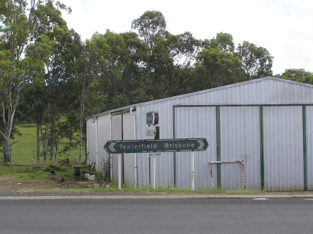
Distance sign heading north from Tenterfield along Mount Lindesay Road. Jan 2005. |
 |
Distance sign heading west from Woodenbong. Jan 2005. |
 |
Black AD sign heading east in Woodenbong approaching the turnoff to Urbenville. Jan 2005. |
 |
Same intersection, this time the westbound AD sign. Jan 2005. |
 |
Remnant "B135" kilometre plate heading north between Woodenbong and Summerland Way. The B stands for Brisbane. Jan 2005. |
 |
Looking north along Summerland Way from its junction with Mt Lindesay Rd. Jan 2005. |
View of the Mount Lindesay Highway on the NSW side of the border with Mt Lindesay in the background, 1955. (DMR) |
|
 |
Old style NSW border sign at Collins Gap (Mount Lindesay). Jan 2005. |
1. Department of Main Roads; ‘Country Main Road Construction – Some Work in hand by Councils’ in Main Roads Vol. 14 No. 2; December 1948; p.62-63
Last updated 5 October 2012 © Ozroads 2003-2012. |