WARRINGAH FREEWAY: Construction Information |
||||||||||||||||||||||
Overview |
The Warringah Freeway (formerly Expressway) is a north-south freeway running for ~4km from the northern approach of the Harbour Bridge at North Sydney to Willoughby Rd at Naremburn. The concept for this freeway was first laid out in the 'County of Cumberland Planning Scheme' (1951), however it was a plan of a much larger scale. The CCPS document proposed that the Warringah Freeway would extend all the way to Seaforth, combining with the duplication of the Wakehurst Parkway to form the backbone of road access to the Northern Beaches. Following the release of the CCPS document, the NSW government began investigatiing and then gazetting the freeway corridors outlined in the proposal. The alignment chosen for the Warringah Freeway turned north at Willoughby Rd, then cut easterly through the suburbs of Willoughby and Castlecrag. It would then cross Middle Harbour between Sugarloaf and Pickering Points on a high level bridge. Once across Middle Harbour, a split into 3 branches was propsed. One into Seaforth in the vicinity of Ellery St for access to Balgowlah/Manly, a second along Burnt Bridge Creek (a corridor which has been partly used by Burnt Bridge Creek Deviation, the Metroad 10 bypass of Balgowlah) to provide access to Brookvale and Dee Why, the third and major branch would continue north, utilising a newly duplicated Wakehurst Parkway. The corridor was gazetted in 1953 and plans even got as far as an Environmental Impact Statement being prepared in 1965 for grade-separation of the Wakehurst Parkway/Warringah Rd intersection.
|
|||||||||||||||||||||
Bradfield Highway to Miller Street |
With the opening of the 2 extra lanes on the Harbour Bridge (replacing the tram tracks in 1959) and the opening of the Cahill Expressway across Circular Quay there was an ever increasing amount of traffic making its own way across the harbour, to and from North Sydney. At this time, all the traffic was squeezed onto the 6-8 lane Pacific Hwy through the middle of North Sydney. a major problem was the high demand for right turn movements, especially into the 4-lane Miller St, with a large percentage of traffic heading towards Cremorne/Mosman via Military Rd, Cammeray/Northbridge via Miller St and into Chatswood/Roseville via Willoughby Rd. The Warringah Freeway was mooted as the answer to these traffic problems. While the first stage would not remove through traffic from the pacific Hwy, it would allow traffic to bypass North Sydney and distribute it to the major Northern Beaches routes. Coupled with the prposed Gore Hill Freeway, through traffic to Lane Cove, Hornsby and points along the Pacific Hwy would eventually be able to bypass North Sydney. The Department of Main Roads had never been able to fully sustain its program of maintainence, reconstruction and moderate new construction, and new sources of revenue were required to finance major new construction projects. Consequently, the Sydney Harbour Bridge (Administration) Act, 1932 was amended in 1960 to enable the Department to use surplus toll revenue for the property acquisition costs of the Warringah Expressway, among other projects, from Ernest St to Bradfield Hwy. Further legislative action was taken to extend the provisions of the Sydney Harbour Bridge (Administration) Act, 1932 by the passing of the Sydney Harbour Bridge (Administration) Amendment Act, 1962. This Act allowed Harbour Bridge toll surpluses to cover the costs of property acquisition costs between Ernest St & Miller St, Cammeray and the cost of construction between Bradfield Hwy and Miller St. While approval had been given to utilise surplus toll revenue from the Sydney Harbour Bridge Account for the acquisition of land for, and the construction of, freeways as approaches to the Sydney Harbour Bridge, it was recognised that the available funds would be insufficient to complete these works and that a further source of funds was required. These funds for the Warringah were raised by a 33% increase in motor vehicle taxation rates in 1962. When serious planning and design was started, the corridor had already been gazetted but what lay in the way of the DMR bulldozers was 1km of densley packed residences along Arthur and Alfred Streets. All of it went, the bulldozers cutting a swathe through North Sydney before reaching the open parkland near Ridge St. Construction began in late 1965, with heavy earthworks required to pass beneath Falcon, Ernest and Miller Streets. At this time, freeway construction was relatively new in NSW and Australia, the Warringah Freeway being easily the most ambitious project undertaken, which it needed to be. Included in the project were some different construction techniques, allowing the Freeway to utilise its maximum potential. Firstly, the entire first stage was constructed with four carriageways in a 3-2-2-3 mainline lane configuration. On/off rmaps and their associated slip lanes were constructed where required. The middle two carriageways were unique in that they were reversible, allowing traffic to travel in either direction depending on the time of day, and including massive sign gantries capable of of changing the sign messages according to the direction in which the carriageway was operating. Movable medians and well-placed on/off ramps allowed a N-S-S-S operation in the morning peak, a N-N-N-S set-up in the afternoon peak and a N-N-S-S setup in offpeak times. For each carriageway, an asphalt surface was used for the travelling lanes and a concrete surface used for the shoulders, creating a high level of delineation. Two bus bays were also constructed between Falcon and Ernest Streets (near the Cremorne Depot) allowing for 'Express'/'via Freeway' buses to change drivers. At the north end, Miller St, a temporary connection was provided to Chandos St until the anticipated extension to Willoughby Rd was completed. Construction of the first stage from Bradfield Hwy, North Sydney to Miller St, Cammeray was opened to traffic in June 1968. The Department of Main Roads prepared a promotional film to commemorate this very significant project. Two short excerpts from this film have been uploaded by the National Film & Sound Archive here and here. I highly recommend clip 2 for the fantastic signage shots.
|
|||||||||||||||||||||
Government Announces Construction Timeframe |
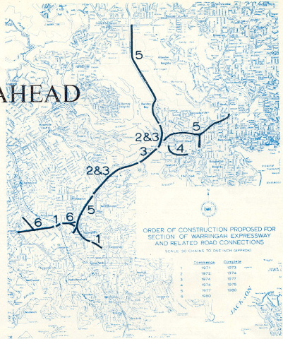
In its June 1970 edition of 'Main Roads' magazine, the Department of Main Roads announced its plans and construction timeline for the Warringah Freeway. Fromt he article 'Looking Ahead': "The Department of Main Roads is planning to construct the Warringah Expressway from the end of the present section at Miller St, Cammeray, through the Warringah and Manly areas by 1980." The map below shows the construction timeline as well as the proposed link to Pacific Hwy & Longueville Rd at Atarmon to be built once the Warringah Freeway is complete. For those who cannot read the timeline clearly those dates are:
|
|||||||||||||||||||||
Stage 1 Construction Delays |
Stage 1 of the above plan, the extension to Willoughby Rd, was subsequently delayed due to lack of funds. Construction was planned to start in 1971 but was put off until April 1973.
|
|||||||||||||||||||||
Freeway Numbering |
During 1974, the DMR unveiled a new numbering system spurned by the rapid expansion of Sydney's freeway system. As part fo this system, the Warringah was given the 'F1' designation. Thism designation was to continue north to its proposed northern terminus at Warringah Rd, Frenchs Forest.
|
|||||||||||||||||||||
Government changes plans |
In August 1977, the NSW Premier, Neville Wran, announced the cancellation of the Warringah Freeway extensions to Seaforth/Frenchs Forest, along with several other freeway corridors within 20km of the City. The NSW government continued construction of the extension to Willoughby Rd and the stated the Gore Hill Freeway proposal 'will be retained as a long-term proposal with a low priority'. This decision came from the results of a Commonwealth Bureau of Roads report conducted in 1974 which assessed the need for the freeway systems then proposed in Australian capital cities. The report had this to say about the Warringah: “An examination of the Warringah Freeway as part of the total system shows a benefit cost ratio less than 0.7 and further construction of this section of freeway, including the crossing of Middle Harbour, would encourage car commuters to the CBD."1
|
|||||||||||||||||||||
Miller Street to Willoughby Road opens |
Meanwhile, construction was slowly progressing (still with provision for a future Northern Beaches extension) with the opening of on/off ramps at brook St in mid-1976. As part of this project, Flat Rock Drive was constructed, linking Brook St with Alpha Rd and providing a bypass of the 2-lane 'Suspension Bridge' on Miller St. The twin 4-lane bridges over Brook St were both built with capacity for 2 extra lanes, allowing for the extension of the freeway north. In this stage, only 2 lanes on each bridge are utilised, the other 2 being opened with the Gore Hill Freeway in 1992. The section from Miller St to Willoughby Rd was opened in September 1978.
|
|||||||||||||||||||||
Tunnel Construction & Added Lanes |
After nearly 10 years of nothing new on the Warringah an injection of federal funding as part of the 'Bocentennial Roads Program' meant the southern terminus recieved a huge makeover. The construction of the Sydney Harbour Tunnel meant a huge reconfiguration of carriageways. The eastern reversible carriageway was made permanently southbound as the apporch to the tunnel and the western-most carriageway was split in 2 between High St and Mount St to make way for the northbound tunnel exit. To cope with the additional traffic crossing the harbour, the shoulders were resumed and made into traffic lanes. Capacity was increased from the original 10-lane mainline to 16 lanes at its widest point beneath Ridge St. A toll plaza was constructed in the southbound (formerly) reversible roadway. During this construction one of the traffic lanes on the eatsern-most carriageway was converted to a BUS ONLY lane extending from the carriageway split near Miller St to the southern extremity of the freeway where it continued across the Bridge via one of the formerly Cahill Expressway lanes. This construction was commenced in May 1987 and completed by August 1992.
|
|||||||||||||||||||||
Gore Hill Freeway Construction |
Beginning in September 1988, the northern extremity of the warringah recieved a major reconstruction. New on/off ramps were constructed at Willoughby Rd, with a depp 4-lane trench dug beneath Willoughby Rd. This was the Gore Hill Freeway, a link to the Pacific Hwy/Longueville Rd intersection at Lane Cove, finally allowing Pacific Hwy traffic to bypass North Sydney. The freeway capacity was increased from 4 to 7 lanes across Brook St, with the work opening to traffic in August 1992. This changed the role of the Warringah Freeway from distributor to radial freeway, as it was once planned to be.
|
|||||||||||||||||||||
Future Improvements & Extensions |
Falcon St North-facing Ramps: In conjunction with the Lane Cove Tunnel project, currently under construction, the Falcon St Interchange will recieve new north-facing ramps, allowing freeway access to/from Military Rd. These ramps will be tolled electronically as part of the Lane Cove Tunnel project, and are expected to open before 2007. Northern Beaches Express Tunnel: The original Warringah Freeway plans have long since been forgotten and the corridor through Willoughby and Castlecrag sold off but still the Northern Beaches cries out for freeway access. Approaching the last election, the Liberals floated several proposals regarding a ~10km express tunnel for access to Seaforth/Balgowlah and points north. Also included in the proposals was a rail tunnel, however, a rail tunnel would have been too deep for any reasonably located stations on the south side of Middle Harbour. My personal preference for this project is to revive the original idea of reaching the Wakehurst Parkway. This could be achieved by a tunnel from the vicnity of Ernest St along an entirely new line beneath Northbridge Golf Course and Sailors Bay. The tunnel could resurface in Seaforth near the southern extremity of the Wakehurst Parkway. Links could be provided to Seaforth (via Frenchs Forest Rd) and to Burnt Bridge Creek Deviation (via the original Burnt Bridge Creek alignment). Wakehurst Parkway could then be duplicated at least as far as Warringah Rd (preferably to Oxford Falls) where a realigned and flood-free Wakehurst Parkway could feed traffic into Pittwater Rd at North Narrabeen. |
|||||||||||||||||||||
1 - Commonwealth Bureau of Roads, Freeway plans of state capital cities, 1974