NATIONAL ROUTE 32
Former alignments: Sydney to Lapstone
From its inception in the mid-1950's, National Route 32 extended the length of State Highway 5 (Great Western Hwy) from City Rd at Ultimo to Bathurst. In the 1970's, the first sections of the Western Freeway (now Motorway) were opened to traffic, taking NR32 away from its original alignment. In September 1992, Metroad 4 was signposted, completely replacing NR32 between Emu Plains and Ultimo and with the opening of the Lapstone Extension of the M4 in June 1993, NR32 was no longer inside the Sydney Metroploitan Area. Below is a comprehensive description of the changes in NR32's alignment within Sydney, up until its complete decomissioning in June 1993.
1954 - National Route 32 proposed to extend from Sydney to Gawler, SA via Gt Western, Mitchell and Barrier Highways
1956/7 - Signposted through Sydney
October 1971 - NR32 re-routed onto Russell St/F4/Bringelly Rd with opening of first section of Western Fwy
December 1972 - NR32 extended east along freeway to Wallgrove Rd
April 1974 - NR32 extended east along freeway to Gt Western Hwy at Prospect
December 1982 - NR32 re-routed from Parramatta Rd onto freeway between Concord Rd, Nth Strathfield & Melton St, Auburn
December 1982 - NR32 bypasses Parramatta along the freeway from Church St to Mays Hill
September 1984 -
NR32 extended along the freeway from Melton St, Auburn to Wentworth St, Clyde
December 1985 - NR32 extended slightly to connect with Parramatta Rd east of Concord Rd
April 1986 - NR32 now travels on continuos freeway from
Concord to Mays Hill, where it rejoins Gt Western Hwy
March 1991 - NR32 extended slightly east to Railway Square
May 1992 - NR32 routed onto new Mays Hill-Prospect section of motorway
Septmeber 1992 - NR32 replaced by Metroad 4 from Emu Plains to Ultimo
June 1993 - M4 extension opens to Lapstone, decomissioning the last section of NR32 in the Sydney Metro Area
Photos of National Route 32 in Sydney |
|
 |
This 2004 photo shows the most recently bypassed section of NR32 near Knapsack Bridge. Thanks to Albert Alcoceba for this photo. |
Taken in August 1993, showing the Emu Plains-Lapstone alignment not long after it was closed. |
|
 |
July 2004 photo showing the old alignment entering Emu Plains at the start of the dual carriageway. |
 |
Sign informing motorists that this road no longer carries through traffic. Photo taken July 2004. |
 |
October 1993 photo showing NR32 shield on Russell St, Emu Plains, an interim alignment leading to the Western Motorway which carried the NR32 shield from 1971-1992. |
 |
February 1994 photo showing similar AD sign, heading in the opposite direction. Note that the sign only shows Sydney, being a relic from the days when the freeway only went east from here. |
 |
Great Western Hwy nameplate showing what was a major turn for NR32 traffic until the M4 Extension opened in June 1993. Photo taken February 1994. |
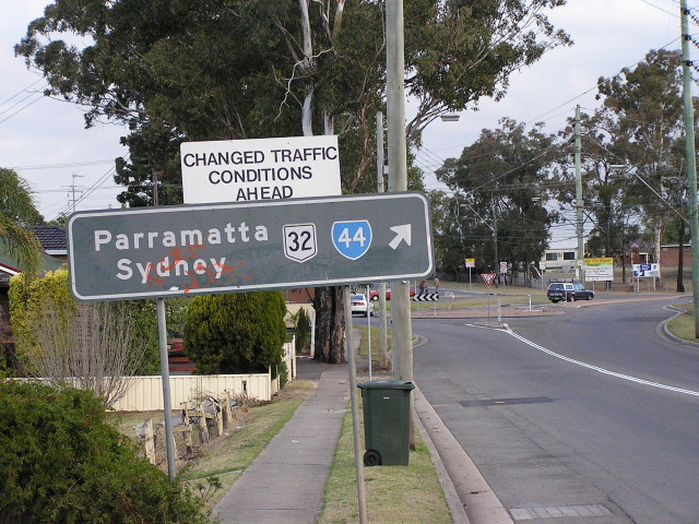 |
The only surviving remnant of NR32 in Sydney, on Blacktown Rd at Prospect, showing the long standing duplex along the Gt Western Hwy at Prospect which existed from 1974-1992. Photo taken July 2004. |
If you closely in this photo you can see a very old NR32 trailblazer, partially hidden behind the Gt Western Hwy sign. This trailblazer probably dates from the 1970's or earlier, which seems to be the time when trailblazers began to disappear from NSW roads. Photo taken 1994 at Pitt St, Parramatta. |
|
 |
Black AD sign that - quite possibly a 1974 installation as it still reads NR32 - pre-dates the Church St to Mays Hill section of the M4. Photo taken Dec 1993. |
 |
September 1992 photo showing a NR32 shield on the ramp to the M4 at Church St, Granville. Also note SR44 is on a coverplate over SR55, which travelled along Church St until 1988. |
 |
NR32 distance sign on the M4 westbound from Church St. Photo taken September 1992, only a matter of weeks before Metroad 4 replaced NR32. |
 |
Remnant black ID sign on the corner of Martha and Wentworth Streets, Granville. NR32 used Martha St as a westbound connection to Parramatta Rd during 1984-86. April 2005. |
 |
1991 photo of NR32 on the freeway approaching Parramatta Rd at Concord. |
 |
Not NR32 specifically, but this is a very old sign from the days when Parramatta Rd was signposted as the Gt Western Hwy. Nowadays, the local name of Parramatta Rd wins out. Photo taken 1992 at the intersection of The Crescent and Johnston St, Rozelle. |
 |
NR31/NR32 duplex signage on New Catnerbury Rd at Crystal St, which leads directly to Parramatta Rd at Petersham. Photo taken 1992. |
 |
Same intersection, this time heading west on Stanmore Rd. Photo taken 1992. |
 |
Same intersection again, this time an ID sign for Crystal St. Note also the SR17 shield which mysteriously appears here, miles away from any other shield. |